|
search place name
|
||
Ban Laothèn (Phôngsali, Laos)Ban Laothèn is a town in the Phôngsali region of Laos. An overview map of the region around Ban Laothèn is displayed below.
regional and 3d topo map of Ban Laothèn, Laos ::
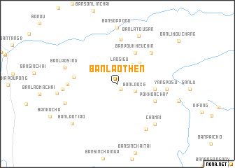
Nearby towns ::
Siêu Schu Pông (0.9km south east) //
Lao Sieu (2.9km north) //
Ban Tasèngpheung (3.0km north) //
Ban Laoxè (2.9km south east) //
Ban Thènphagna (3.8km north east) //
Ban Ukouaysing (4.1km north east) //
Ban Laothian (4.6km north east) //
Ban Voukheuchin (5.6km north east) //
Thiên Thang (5.6km east) //
Po Khoa Chay (6.2km south east) //
Lao T'seu (6.5km west) //
Ban Khônhi (7.1km north) //
Ban Limungchai (7.1km north east) //
Yang Po Su (7.4km east) //
Ban Laosing (7.4km west) //
Ban Latousan (8.2km north) //
Ban Yaofang (8.4km south east) //
Cha Mai (8.5km south east) //
Ban Laosing (8.2km west) //
Lô Phya (8.2km west) //
Ban Kotayé (8.4km west) //
Ban Laotiao (9.2km south west) //
[all distances 'as the bird flies' and approximate] 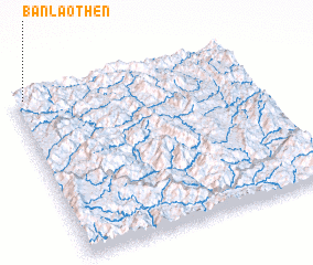 Places with similar names to Ban Laothèn, Laos ::
// Ban Laothian (LA)
Disclaimer :: Information on this page comes without warranty of any kind |
||
|
Where is Ban Laothèn? Elevation and coordinates ::
Latitude (lat): 21°59'27"N Longitude (lon): 102°2'45"E
Elevation (approx.): 1135m (map arrows pan, magnifying glasses zoom) |
||
|
Visiting Ban Laothèn? Hotel/Accommodation ::
Book a hotel in Ban Laothèn Travel Guide ::
Buy a travel guide for Laos rental cars ::
car rental offers GPS waypoint ::
download a GPX waypoint (PoI) of Ban Laothèn for your GPS receiver
|
||