|
search place name
|
||
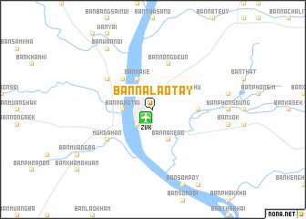
Ban Nalaotay (Laos)Ban Nalaotay is a town in Laos. An overview map of the region around Ban Nalaotay is displayed below.
regional and 3d topo map of Ban Nalaotay, Laos ::
Ban Nalaotay airports ::
The nearest airport is ZVK - Savannakhet, located 1.4 km south west of Ban Nalaotay.
Other airports nearby include SNO - Sakon Nakhon (98.0 km north west), PKZ - Pakse (192.4 km south east), UTH - Udon Thani (229.4 km north west), Nearby towns ::
Savannakhét (2.6km south west) //
Ban Na Po Tai (3.6km west) //
Ban Nongphu (4.0km north east) //
Ban Nakè (4.1km north west) //
Ban Naxéng (4.1km south east) //
Ban Na Po Yai (4.0km north west) //
Ban Sai Yai (5.1km north west) //
Ban Palai (5.3km east) //
Ban Bungva (5.3km east) //
Ban Nongdeun (5.8km north) //
Ban Khok Sung (6.5km north west) //
Mukdahan (6.5km south west) //
Ban Wan Noi (9.1km north west) //
Ban Phaluka Tai (9.1km north west) //
[all distances 'as the bird flies' and approximate] 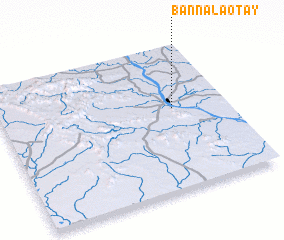 Places with similar names to Ban Nalaotay, Laos ::
Disclaimer :: Information on this page comes without warranty of any kind |
||
|
Where is Ban Nalaotay? Elevation and coordinates ::
Latitude (lat): 16°34'0"N Longitude (lon): 104°46'0"E
Elevation (approx.): 159m (map arrows pan, magnifying glasses zoom) |
||
|
Visiting Ban Nalaotay? Hotel/Accommodation ::
Book a hotel in Ban Nalaotay Travel Guide ::
Buy a travel guide for Laos rental cars ::
car rental offers GPS waypoint ::
download a GPX waypoint (PoI) of Ban Nalaotay for your GPS receiver
|
||