|
search place name
|
||
Ban Phadèng-Noy (Phôngsali, Laos)Ban Phadèng-Noy is a town in the Phôngsali region of Laos. An overview map of the region around Ban Phadèng-Noy is displayed below.
regional and 3d topo map of Ban Phadèng-Noy, Laos ::

Ban Phadèng-Noy airports ::
The nearest airport is LPQ - Luang Prabang Luang Phabang Intl, located 220.2 km south of Ban Phadèng-Noy.
Other airports nearby include THL - Tachilek Tachileik (243.7 km south west), Nearby towns ::
Ban Salaoutya (2.7km north west) //
Ban Phatong-Mai (4.9km north west) //
Ban Khapousa-Noy (5.3km south east) //
Ban Phouxa-Nua (6.2km east) //
Ban Khapousa (6.3km east) //
Ban Phouxa (7.2km south east) //
Ban Mai-Naliveuy (7.6km south) //
Ban Kheusan (7.6km north) //
Xieng Py (7.4km south east) //
Ban Xiangdao (7.3km south east) //
Yang Phya (8.2km south) //
Ban Boké (8.3km north) //
Ban Lontan (9.1km north east) //
Ban Yakhu (10.4km north west) //
[all distances 'as the bird flies' and approximate] 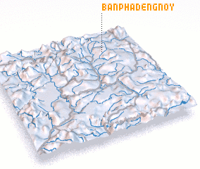 Places with similar names to Ban Phadèng-Noy, Laos ::
Disclaimer :: Information on this page comes without warranty of any kind |
||
|
Where is Ban Phadèng-Noy? Elevation and coordinates ::
Latitude (lat): 21°51'11"N Longitude (lon): 101°46'22"E
Elevation (approx.): 1059m (map arrows pan, magnifying glasses zoom) |
||
|
Visiting Ban Phadèng-Noy? Hotel/Accommodation ::
Book a hotel in Ban Phadèng-Noy Travel Guide ::
Buy a travel guide for Laos rental cars ::
car rental offers GPS waypoint ::
download a GPX waypoint (PoI) of Ban Phadèng-Noy for your GPS receiver
|
||