|
search place name
|
||
Ban Poungxoung (Laos)Ban Poungxoung is a town in Laos. An overview map of the region around Ban Poungxoung is displayed below.
regional and 3d topo map of Ban Poungxoung, Laos ::

Ban Poungxoung airports ::
The nearest airport is SNO - Sakon Nakhon, located 154.7 km south of Ban Poungxoung.
Other airports nearby include VTE - Vientiane Wattay Intl (204.5 km west), UTH - Udon Thani (215.0 km south west), Nearby towns ::
Ban Kôkkham (2.6km north west) //
Ban Sôp-Ha (2.6km south east) //
Ban Sôpso (6.6km north east) //
Ban Houay-Hoy (6.6km north west) //
Ban Ta Re (8.2km south east) //
Ban Pakha (7.9km south west) //
[all distances 'as the bird flies' and approximate] 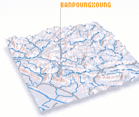 Places with similar names to Ban Poungxoung, Laos ::
// Ban Pong Kasang (TH)
// Ban Pongxang (LA)
// Ban Pongxang (LA)
// Ban Poungxèng (LA)
// Bản Púng Xăng (VN)
Disclaimer :: Information on this page comes without warranty of any kind |
||
|
Where is Ban Poungxoung? Elevation and coordinates ::
Latitude (lat): 18°34'0"N Longitude (lon): 104°24'0"E
Elevation (approx.): 315m (map arrows pan, magnifying glasses zoom) |
||
|
Visiting Ban Poungxoung? Hotel/Accommodation ::
Book a hotel in Ban Poungxoung Travel Guide ::
Buy a travel guide for Laos rental cars ::
car rental offers GPS waypoint ::
download a GPX waypoint (PoI) of Ban Poungxoung for your GPS receiver
|
||