|
search place name
|
||
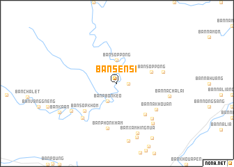
Ban Sènsi (Laos)Ban Sènsi is a town in Laos. An overview map of the region around Ban Sènsi is displayed below.
regional and 3d topo map of Ban Sènsi, Laos ::
Ban Sènsi airports ::
The nearest airport is SNO - Sakon Nakhon, located 151.8 km south west of Ban Sènsi.
Other airports nearby include ZVK - Savannakhet (197.3 km south), Nearby towns ::
Ban Sôptong (1.8km east) //
Ban Pbônkèo (3.2km south west) //
Ban Sôppông (3.7km north) //
Ban Sôppông (5.6km east) //
Ban Xamteuy-Nua (6.6km south east) //
Ban Sôpkhôm (6.6km south west) //
Ban Phônkham (7.4km south) //
Ban Nakhouan (7.3km south east) //
Ban Namtong (7.3km east) //
Ban Fan (7.7km south west) //
Ban Xamteuy-Tai (7.8km south east) //
Ban Phônsa-At (8.2km south west) //
Ban Kôngphat (8.4km south east) //
Ban Xamhīng-Nua (8.6km south) //
Ban Nachalai (8.3km east) //
Ban Xamhing-Tai (9.2km south) //
Ban Phônxai (10.3km south east) //
[all distances 'as the bird flies' and approximate]  Places with similar names to Ban Sènsi, Laos ::
// Beinsnes (NO)
// Bønsnes (NO)
// Ban San Sai (TH)
// Ban San Sai (TH)
// Ban San Sai (TH)
// Ban San Sai (TH)
// Ban San Sai (TH)
// Ban Sansai (TH)
// Ban Suan Sa (TH)
// Binnsounsou (CG)
Disclaimer :: Information on this page comes without warranty of any kind |
||
|
Where is Ban Sènsi? Elevation and coordinates ::
Latitude (lat): 18°20'0"N Longitude (lon): 104°55'0"E
Elevation (approx.): 513m (map arrows pan, magnifying glasses zoom) |
||
|
Visiting Ban Sènsi? Hotel/Accommodation ::
Book a hotel in Ban Sènsi Travel Guide ::
Buy a travel guide for Laos rental cars ::
car rental offers GPS waypoint ::
download a GPX waypoint (PoI) of Ban Sènsi for your GPS receiver
|
||