|
search place name
|
||
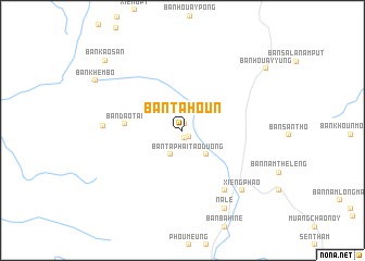
Ban Tahoun (Phôngsali, Laos)Ban Tahoun is a town in the Phôngsali region of Laos. An overview map of the region around Ban Tahoun is displayed below.
regional and 3d topo map of Ban Tahoun, Laos ::
Ban Tahoun airports ::
The nearest airport is LPQ - Luang Prabang Luang Phabang Intl, located 200.7 km south of Ban Tahoun.
Other airports nearby include THL - Tachilek Tachileik (240.5 km south west), Nearby towns ::
Ban Kiou (0.6km north) //
Xieng Fa (0.8km south east) //
Sen Luong Chang (0.8km south east) //
Ban Noy (0.9km south) //
Ban Panghôk (2.1km north east) //
Ban Ta Phaï (2.7km south west) //
Tao Duong (3.4km south east) //
Ban Dao-Tai (5.5km west) //
Boun Nua (7.4km south east) //
Ban Dao-Nua (7.6km west) //
Xieng Phao (8.4km south east) //
Na Lè (9.0km south east) //
Ban Khèmbo (9.7km north west) //
Ban Houayyung (10.2km north east) //
Ban Kaosan (10.3km north west) //
[all distances 'as the bird flies' and approximate]  Places with similar names to Ban Tahoun, Laos ::
// Ban Du Hun (TH)
// Ban Na Ta Hin (TH)
// Bintuhan (ID)
// Bendehun (SL)
// Benduhun (SL)
// Bondehun (SL)
// Ban Tahon (LA)
// Ban Tao Hinh (LA)
// Ban Tohoun (LA)
// Benoudhianá (GR)
Disclaimer :: Information on this page comes without warranty of any kind |
||
|
Where is Ban Tahoun? Elevation and coordinates ::
Latitude (lat): 21°41'20"N Longitude (lon): 101°51'40"E
Elevation (approx.): 964m (map arrows pan, magnifying glasses zoom) |
||
|
Visiting Ban Tahoun? Hotel/Accommodation ::
Book a hotel in Ban Tahoun Travel Guide ::
Buy a travel guide for Laos rental cars ::
car rental offers GPS waypoint ::
download a GPX waypoint (PoI) of Ban Tahoun for your GPS receiver
|
||