|
search place name
|
||
Ban Takôchiang (Phôngsali, Laos)Ban Takôchiang is a town in the Phôngsali region of Laos. An overview map of the region around Ban Takôchiang is displayed below.
regional and 3d topo map of Ban Takôchiang, Laos ::
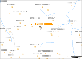
Nearby towns ::
Ban Bokhoun (3.6km north east) //
Ban Pé (3.9km west) //
Ban Chinkan (4.7km north west) //
Tong Koua Lin (4.7km south east) //
Ban Peuhoasoung (5.2km south east) //
Ban Malitao (6.5km north east) //
Ban Mai-Nahôk (6.9km west) //
Ban Tongkoualin (7.3km east) //
Ban Tafousan (7.5km east) //
Ban Sinchai (8.3km south) //
Ban Kinchoulin (8.1km south east) //
Ban Khaophagna (9.3km north) //
[all distances 'as the bird flies' and approximate] 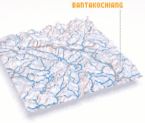 Places with similar names to Ban Takôchiang, Laos ::
// Ban Dakchung (LA)
Disclaimer :: Information on this page comes without warranty of any kind |
||
|
Where is Ban Takôchiang? Elevation and coordinates ::
Latitude (lat): 22°18'4"N Longitude (lon): 101°56'31"E
Elevation (approx.): 1323m (map arrows pan, magnifying glasses zoom) |
||
|
Visiting Ban Takôchiang? Hotel/Accommodation ::
Book a hotel in Ban Takôchiang Travel Guide ::
Buy a travel guide for Laos rental cars ::
car rental offers GPS waypoint ::
download a GPX waypoint (PoI) of Ban Takôchiang for your GPS receiver
|
||