|
search place name
|
||
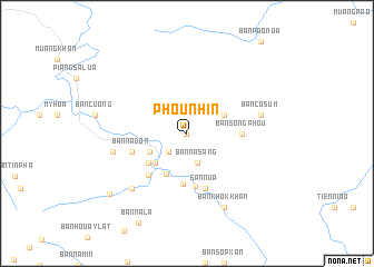
Phou Nhin (Houaphan, Laos)Phou Nhin is a town in the Houaphan region of Laos. An overview map of the region around Phou Nhin is displayed below.
regional and 3d topo map of Phou Nhin, Laos ::
Phou Nhin airports ::
The nearest airport is HAN - Hanoi Noibai Intl, located 178.6 km north east of Phou Nhin.
Nearby towns ::
Ban Tao (0.0km north) //
Ban Thin (2.5km south west) //
Ban Nasang (3.1km south) //
Ban Coleu (3.9km north east) //
Ban Kho (3.9km south west) //
Ban Xamthong (4.2km south west) //
Ban Matkai (4.6km south west) //
Ban Xamti (4.7km south west) //
Ban Muangphat (5.1km south) //
Ban Phiangkham (5.3km south) //
Ban Song Phou (5.2km east) //
Ban Sôpxa (5.5km south west) //
San Nua (5.8km south) //
Ban Nadon (5.5km west) //
Ban Co Sum (7.2km east) //
Ban Houay Kut (7.2km west) //
Ban Houaykout (7.6km south west) //
Ban Khokkhan (8.2km south east) //
Ban Houaykik (9.6km south west) //
[all distances 'as the bird flies' and approximate]  Places with similar names to Phou Nhin, Laos ::
Disclaimer :: Information on this page comes without warranty of any kind |
||
|
Where is Phou Nhin? Elevation and coordinates ::
Latitude (lat): 20°1'0"N Longitude (lon): 104°40'0"E
Elevation (approx.): 788m (map arrows pan, magnifying glasses zoom) |
||
|
Visiting Phou Nhin? Hotel/Accommodation ::
Book a hotel in Phou Nhin Travel Guide ::
Buy a travel guide for Laos rental cars ::
car rental offers GPS waypoint ::
download a GPX waypoint (PoI) of Phou Nhin for your GPS receiver
|
||