|
search place name
|
||
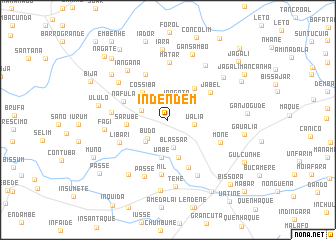
Indendem (Oio, Guinea-Bissau)Indendem is a town in the Oio region of Guinea-Bissau. An overview map of the region around Indendem is displayed below.
regional and 3d topo map of Indendem, Guinea-Bissau ::
Indendem airports ::
The nearest airport is BXO - Bissau Oswaldo Vieira Intl, located 46.2 km south of Indendem.
Other airports nearby include ZIG - Ziguinchor (89.0 km west), CSK - Cap Skiring (135.1 km west), BJL - Banjul Intl (169.9 km north west), KLC - Kaolack (213.8 km north), Nearby towns ::
Iongotô (2.3km north east) //
Ualia (3.0km east) //
Budo (3.0km south west) //
Blassar (3.1km south) //
Cossicunto (3.1km west) //
Uaqueri (3.5km south west) //
Cossiba (4.1km north west) //
Uabe (4.3km south) //
Blassar (4.4km south) //
Bucaur (4.6km north east) //
Sarubè (4.6km west) //
Nafula (5.3km north west) //
Binaga (5.6km north west) //
Jabel (5.6km north east) //
Sorimone (5.7km south east) //
Libari (5.9km south west) //
Mil (6.1km south) //
Mone (6.2km south east) //
Quijim (6.2km west) //
Matar (6.4km north) //
Passe (6.8km south) //
Damberá (6.8km north west) //
Missirá (7.0km south east) //
Ianganã (7.1km north west) //
Fagi (7.0km west) //
Nhanfa (7.3km north east) //
Tehé (7.5km south) //
Lípete (7.5km south west) //
Cussondome (7.7km north east) //
[all distances 'as the bird flies' and approximate] 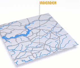 Places with similar names to Indendem, Guinea-Bissau ::
// Induna Timbe (MZ)
// Intindumbo (GW)
Disclaimer :: Information on this page comes without warranty of any kind |
||
|
Where is Indendem? Elevation and coordinates ::
Latitude (lat): 12°17'17"N Longitude (lon): 15°30'37"W
Elevation (approx.): 26m (map arrows pan, magnifying glasses zoom) |
||
|
Visiting Indendem? Hotel/Accommodation ::
Book a hotel in Indendem Travel Guide ::
rental cars ::
car rental offers GPS waypoint ::
download a GPX waypoint (PoI) of Indendem for your GPS receiver
|
||