|
search place name
|
||
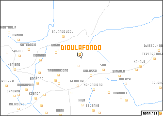
Dioulafondo (Koulikoro, Mali)Dioulafondo is a town in the Koulikoro region of Mali. An overview map of the region around Dioulafondo is displayed below.
regional and 3d topo map of Dioulafondo, Mali ::
Dioulafondo airports ::
The nearest airport is BKO - Bamako Senou, located 48.7 km east of Dioulafondo.
Nearby towns ::
Bèrèla (1.9km south) //
Kalassa (4.6km south east) //
Dogoro (5.6km west) //
Sibi (5.7km south east) //
Kouroubala (5.8km west) //
Géouéna (6.5km south) //
Balandougou (6.5km north west) //
Tabaninkoro (6.5km south west) //
Diélibani (7.7km south west) //
Makandiana (7.8km south) //
Kaka (7.9km south west) //
Tabou (8.4km south) //
Sindala (9.5km south east) //
Kongola (10.1km south east) //
Baro (11.9km south west) //
[all distances 'as the bird flies' and approximate] 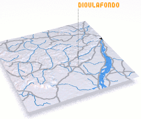 Places with similar names to Dioulafondo, Mali ::
// Delvinta (US)
// Tolvandī (IR)
// Dilafoundou (GN)
// Tall Afandī (SY)
// Dialafoundou (ML)
// Dioulafandou (ML)
// Dioulafondo (ML)
// Dioulafondou (ML)
// Dioulafoundou (ML)
// Dioulafoundou (ML)
Disclaimer :: Information on this page comes without warranty of any kind |
||
|
Where is Dioulafondo? Elevation and coordinates ::
Latitude (lat): 12°24'26"N Longitude (lon): 8°22'45"W
Elevation (approx.): 455m (map arrows pan, magnifying glasses zoom) |
||
|
Visiting Dioulafondo? Hotel/Accommodation ::
Book a hotel in Dioulafondo Travel Guide ::
Buy a travel guide for Mali rental cars ::
car rental offers GPS waypoint ::
download a GPX waypoint (PoI) of Dioulafondo for your GPS receiver
|
||