|
search place name
|
||
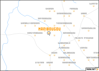
Maribougou (Mali)Maribougou is a town in Mali. An overview map of the region around Maribougou is displayed below.
regional and 3d topo map of Maribougou, Mali ::
Maribougou airports ::
The nearest airport is BKO - Bamako Senou, located 86.0 km south east of Maribougou.
Nearby towns ::
Fodébougou (1.8km east) //
Garabougou (1.8km east) //
Didna (2.6km north west) //
Bayabougou (4.1km north east) //
Kondyiribougou (5.4km west) //
Safinébougou (5.8km north) //
Tiéssémabougou (6.6km north east) //
Boala (6.6km north east) //
Djibouroula (6.6km south east) //
Moromoro (6.6km north west) //
Soniébougou (7.2km east) //
Guissoumalé (7.4km south) //
Sidoni (7.6km south) //
Flabougou (7.8km south east) //
Siramanbougou (9.2km north east) //
Néguélabougou (10.3km north east) //
Wolobougou (10.3km south east) //
[all distances 'as the bird flies' and approximate] 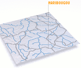 Places with similar names to Maribougou, Mali ::
// Marbeck (DE)
// Meerbeck (DE)
// Meerbeck (DE)
// Merbeck (DE)
// Moorbek (DE)
// Meiribakki (IS)
// Mīrah Bak (IQ)
// Morobogo (BF)
// Muri Baihk (IN)
// Moribougou (MR)
Disclaimer :: Information on this page comes without warranty of any kind |
||
|
Where is Maribougou? Elevation and coordinates ::
Latitude (lat): 13°9'0"N Longitude (lon): 8°26'0"W
Elevation (approx.): 338m (map arrows pan, magnifying glasses zoom) |
||
|
Visiting Maribougou? Hotel/Accommodation ::
Book a hotel in Maribougou Travel Guide ::
Buy a travel guide for Mali rental cars ::
car rental offers GPS waypoint ::
download a GPX waypoint (PoI) of Maribougou for your GPS receiver
|
||