|
search place name
|
||
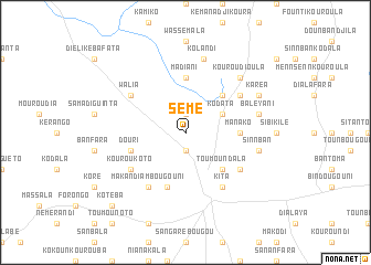
Sémé (Mali)Sémé is a town in Mali. An overview map of the region around Sémé is displayed below.
regional and 3d topo map of Sémé, Mali ::
Sémé airports ::
The nearest airport is BKO - Bamako Senou, located 181.3 km east of Sémé.
Other airports nearby include KYS - Kayes Dag Dag (255.0 km north west), Nearby towns ::
Baraninnba (1.9km north) //
Boudofo (1.9km south) //
Kodata (4.1km north east) //
Kénéroba (4.1km north east) //
Toumoundala (5.2km south east) //
Biladougou (5.2km north east) //
Manako (5.4km east) //
Madiani (5.6km north) //
Fodébougou (5.8km south) //
Douri (5.7km west) //
Makandiambougouni (6.6km south west) //
Kouroukoto (6.6km south west) //
Farada (6.6km south west) //
Diatalabé (6.6km south east) //
Walia (6.6km north west) //
Dialéani (6.6km north east) //
Kita (6.6km south east) //
Baléyani (7.5km east) //
Kolandi (7.6km north) //
Sinnban (7.5km east) //
Kénéma Nadji (7.6km north) //
Kouroudioula (7.8km north east) //
Karéa (8.1km north east) //
Koté Ba (10.3km south west) //
[all distances 'as the bird flies' and approximate] 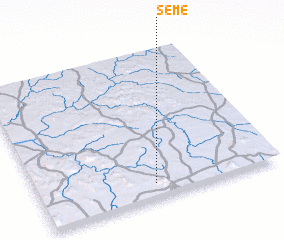 Places with similar names to Sémé, Mali ::
Disclaimer :: Information on this page comes without warranty of any kind |
||
|
Where is Sémé? Elevation and coordinates ::
Latitude (lat): 13°6'0"N Longitude (lon): 9°31'0"W
Elevation (approx.): 331m (map arrows pan, magnifying glasses zoom) |
||
|
Visiting Sémé? Hotel/Accommodation ::
Book a hotel in Sémé Travel Guide ::
Buy a travel guide for Mali rental cars ::
car rental offers GPS waypoint ::
download a GPX waypoint (PoI) of Sémé for your GPS receiver
|
||