|
search place name
|
||
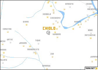
Chiolo (Gaza, Mozambique)Chiolo is a town in the Gaza region of Mozambique. An overview map of the region around Chiolo is displayed below.
regional and 3d topo map of Chiolo, Mozambique ::
Chiolo airports ::
The nearest airport is SZK - Skukuza, located 123.3 km south west of Chiolo.
Other airports nearby include PHW - Phalaborwa (136.7 km west), HDS - Hoedspruit Afb (145.6 km west), MPM - Maputo (191.6 km south), Nearby towns ::
Canahana (2.3km north east) //
Dumbane (3.0km east) //
Tchaiate (3.6km north east) //
Maiane (4.6km north) //
Aldeia Comunais III Congresso (4.9km north east) //
Tique (5.0km south west) //
Uadjoene (5.7km north east) //
Chicavene (5.9km north east) //
Vembela (6.9km north) //
Zua (8.4km south) //
Matchinguetchingue (7.9km south west) //
Mequenetai (8.2km south west) //
Mucatine (8.6km north) //
Manuel (8.5km south west) //
Namborrete (8.5km south west) //
Oxane (8.9km north west) //
[all distances 'as the bird flies' and approximate]  Places with similar names to Chiolo, Mozambique ::
Disclaimer :: Information on this page comes without warranty of any kind |
||
|
Where is Chiolo? Elevation and coordinates ::
Latitude (lat): 24°11'36"S Longitude (lon): 32°28'13"E
Elevation (approx.): 77m (map arrows pan, magnifying glasses zoom) |
||
|
Visiting Chiolo? Hotel/Accommodation ::
Book a hotel in Chiolo Travel Guide ::
Buy a travel guide for Mozambique rental cars ::
car rental offers GPS waypoint ::
download a GPX waypoint (PoI) of Chiolo for your GPS receiver
|
||