|
search place name
|
||
Chitanga (Gaza, Mozambique)Chitanga is a town in the Gaza region of Mozambique. An overview map of the region around Chitanga is displayed below.
regional and 3d topo map of Chitanga, Mozambique ::

Chitanga airports ::
The nearest airport is BFO - Chiredzi Buffalo Range, located 126.2 km north west of Chitanga.
Other airports nearby include PHW - Phalaborwa (240.7 km south west), MVZ - Masvingo Intl (255.4 km north west), LTA - Tzaneen (279.3 km south west), Nearby towns ::
Gandaganga (3.2km south east) //
Mapulango (4.1km north west) //
Matombozano (5.4km north west) //
Chefe Malonguete (6.0km south east) //
Cala (10.3km south east) //
[all distances 'as the bird flies' and approximate] 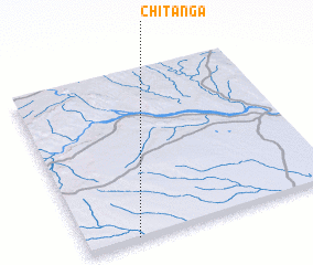 Places with similar names to Chitanga, Mozambique ::
// Shadaing (MM)
// Shadawng Ga (MM)
// Shadeing (MM)
// Shawdaung (MM)
// Shawdaung (MM)
// Shittaung (MM)
// Chatanika (US)
// Shadynook (US)
// Shady Nook (US)
// Chotyniec (PL)
Disclaimer :: Information on this page comes without warranty of any kind |
||
|
Where is Chitanga? Elevation and coordinates ::
Latitude (lat): 21°59'23"S Longitude (lon): 32°11'51"E
Elevation (approx.): 254m (map arrows pan, magnifying glasses zoom) |
||
|
Visiting Chitanga? Hotel/Accommodation ::
Book a hotel in Chitanga Travel Guide ::
Buy a travel guide for Mozambique rental cars ::
car rental offers GPS waypoint ::
download a GPX waypoint (PoI) of Chitanga for your GPS receiver
|
||