|
search place name
|
||
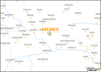
Gachaca (Maputo, Mozambique)Gachaca is a town in the Maputo region of Mozambique. An overview map of the region around Gachaca is displayed below.
regional and 3d topo map of Gachaca, Mozambique ::
Gachaca airports ::
The nearest airport is SZK - Skukuza, located 82.3 km south west of Gachaca.
Other airports nearby include HDS - Hoedspruit Afb (121.2 km west), PHW - Phalaborwa (126.5 km north west), MPM - Maputo (160.1 km south), LTA - Tzaneen (207.9 km west), Nearby towns ::
Andre (2.6km north east) //
Jochiua (2.8km north west) //
Fumuana (3.1km north east) //
Massiei (4.3km south west) //
Mussauene (4.9km south east) //
Mangunguane (5.3km north) //
Zaqueu (5.2km north west) //
Mussalene (5.4km south east) //
Mongoni (5.4km east) //
Olhófo (5.9km west) //
Bongolo (6.5km south) //
Samuel (6.9km north) //
Santa Quitéria (6.4km south east) //
Livasse (7.6km north west) //
Panhine (7.8km north east) //
Machila (8.5km south west) //
Chiquice (8.9km south east) //
Dʼgine (9.5km north) //
Manuel (9.6km north west) //
Fotiche (11.9km north west) //
[all distances 'as the bird flies' and approximate] 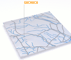 Places with similar names to Gachaca, Mozambique ::
Disclaimer :: Information on this page comes without warranty of any kind |
||
|
Where is Gachaca? Elevation and coordinates ::
Latitude (lat): 24°30'32"S Longitude (lon): 32°14'2"E
Elevation (approx.): 150m (map arrows pan, magnifying glasses zoom) |
||
|
Visiting Gachaca? Hotel/Accommodation ::
Book a hotel in Gachaca Travel Guide ::
Buy a travel guide for Mozambique rental cars ::
car rental offers GPS waypoint ::
download a GPX waypoint (PoI) of Gachaca for your GPS receiver
|
||