|
search place name
|
||
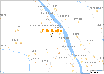
Mabalene (Gaza, Mozambique)Mabalene is a town in the Gaza region of Mozambique. An overview map of the region around Mabalene is displayed below.
regional and 3d topo map of Mabalene, Mozambique ::
Mabalene airports ::
The nearest airport is SZK - Skukuza, located 140.4 km south west of Mabalene.
Other airports nearby include PHW - Phalaborwa (172.8 km west), MPM - Maputo (176.6 km south), HDS - Hoedspruit Afb (177.5 km west), Nearby towns ::
Joane (2.9km east) //
Maguco (3.2km north east) //
Aldeia Comunais 25 de Setembro (3.7km north west) //
Maguequene (3.6km east) //
Massombe (4.0km north west) //
Gelene (4.5km south) //
Chilengue (4.4km east) //
Languane (5.3km north) //
Chate (5.8km south) //
Chate (6.2km south) //
Elias (6.1km north west) //
Injovo (6.2km north east) //
Macarretane (7.0km south east) //
Majejamela (7.7km north) //
Chau-Chau (7.8km south) //
Duco (7.9km north) //
Chicholo (7.8km north east) //
Mulico (8.4km south west) //
Justino (9.3km south east) //
Macarretane (9.1km south east) //
Mulamula (10.2km south west) //
Barragem (10.8km south east) //
[all distances 'as the bird flies' and approximate] 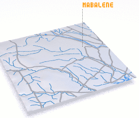 Places with similar names to Mabalene, Mozambique ::
Disclaimer :: Information on this page comes without warranty of any kind |
||
|
Where is Mabalene? Elevation and coordinates ::
Latitude (lat): 24°20'22"S Longitude (lon): 32°47'51"E
Elevation (approx.): 41m (map arrows pan, magnifying glasses zoom) |
||
|
Visiting Mabalene? Hotel/Accommodation ::
Book a hotel in Mabalene Travel Guide ::
Buy a travel guide for Mozambique rental cars ::
car rental offers GPS waypoint ::
download a GPX waypoint (PoI) of Mabalene for your GPS receiver
|
||