|
search place name
|
||
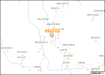
Magudo (Manica, Mozambique)Magudo is a town in the Manica region of Mozambique. An overview map of the region around Magudo is displayed below.
regional and 3d topo map of Magudo, Mozambique ::
Magudo airports ::
The nearest airport is BEW - Beira, located 168.2 km east of Magudo.
Other airports nearby include BFO - Chiredzi Buffalo Range (219.0 km south west), Nearby towns ::
Maeba (1.2km south) //
Padongo (1.7km east) //
Manhandure (2.0km south) //
Muiapi (2.2km north east) //
António (2.2km north west) //
Chacoma (2.2km north east) //
Umbassena (2.8km north east) //
Mʼcequia (2.7km west) //
Muzanga (3.2km west) //
Assiengana (3.8km north) //
Facanhe (3.8km south east) //
Govemende (4.1km west) //
Machanguie (4.5km south west) //
Covideva (5.5km north) //
Fafetine (5.8km south west) //
Machango (6.4km north west) //
Uache (6.7km south east) //
Naveneque (6.6km south east) //
Mapira (6.9km south west) //
Zinesse (7.0km south west) //
Marcopo (8.0km south east) //
Buzana (8.8km south east) //
Dundo (8.8km south east) //
Xicombo (9.2km south east) //
[all distances 'as the bird flies' and approximate] 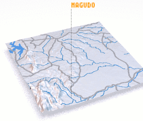 Places with similar names to Magudo, Mozambique ::
Disclaimer :: Information on this page comes without warranty of any kind |
||
|
Where is Magudo? Elevation and coordinates ::
Latitude (lat): 19°52'58"S Longitude (lon): 33°18'17"E
Elevation (approx.): 152m (map arrows pan, magnifying glasses zoom) |
||
|
Visiting Magudo? Hotel/Accommodation ::
Book a hotel in Magudo Travel Guide ::
Buy a travel guide for Mozambique rental cars ::
car rental offers GPS waypoint ::
download a GPX waypoint (PoI) of Magudo for your GPS receiver
|
||