|
search place name
|
||
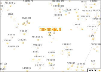
Mahanhela (Inhambane, Mozambique)Mahanhela is a town in the Inhambane region of Mozambique. An overview map of the region around Mahanhela is displayed below.
regional and 3d topo map of Mahanhela, Mozambique ::
Mahanhela airports ::
The nearest airport is VNX - Vilankulu Vilankulo, located 104.2 km south east of Mahanhela.
Other airports nearby include BEW - Beira (207.6 km north), Nearby towns ::
Régulo Cubime (1.4km south east) //
Suacane (1.7km north east) //
Silva (2.0km north east) //
Zualane (2.1km north) //
Muchotane (2.4km south) //
Macungane (4.6km west) //
Zefanias (6.3km south west) //
Mangomanhane (6.9km south east) //
Josefa (7.2km south) //
Fambane (7.4km north east) //
Chavane (7.1km south east) //
Chichavane (7.6km east) //
Chipumessane (8.0km south east) //
Faife (8.5km south west) //
Casamuia (8.8km south east) //
Nhamazane (8.9km north west) //
Muconane (9.5km south west) //
Ganana (9.6km north east) //
Espanela (9.5km south east) //
Nheoane (9.6km north west) //
Navelane (9.9km north west) //
Filipe (10.6km south west) //
Jacob (10.7km north east) //
[all distances 'as the bird flies' and approximate]  Places with similar names to Mahanhela, Mozambique :: Disclaimer :: Information on this page comes without warranty of any kind |
||
|
Where is Mahanhela? Elevation and coordinates ::
Latitude (lat): 21°36'39"S Longitude (lon): 34°24'19"E
Elevation (approx.): 168m (map arrows pan, magnifying glasses zoom) |
||
|
Visiting Mahanhela? Hotel/Accommodation ::
Book a hotel in Mahanhela Travel Guide ::
Buy a travel guide for Mozambique rental cars ::
car rental offers GPS waypoint ::
download a GPX waypoint (PoI) of Mahanhela for your GPS receiver
|
||