|
search place name
|
||
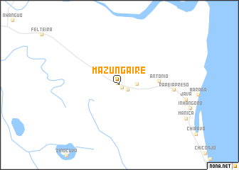
Mazungaire (Sofala, Mozambique)Mazungaire is a town in the Sofala region of Mozambique. An overview map of the region around Mazungaire is displayed below.
regional and 3d topo map of Mazungaire, Mozambique ::
Mazungaire airports ::
The nearest airport is BEW - Beira, located 37.0 km north east of Mazungaire.
Nearby towns ::
Cherimonha (0.3km north west) //
Nhamucia (0.6km south east) //
Chamba (1.5km south east) //
Chipacajana (2.6km east) //
António (5.9km east) //
Rapeia Preso (8.2km east) //
[all distances 'as the bird flies' and approximate] 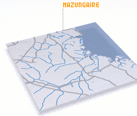 Places with similar names to Mazungaire, Mozambique ::
// Mosainagar (BD)
// Massangari (BJ)
// Mesonkoré (GA)
// Mazingara (TZ)
// Mūsanagar (PK)
// Massinguir (MZ)
// Masingara (PG)
// Masankere (SL)
// Masankori (SL)
// Masankori (SL)
Disclaimer :: Information on this page comes without warranty of any kind |
||
|
Where is Mazungaire? Elevation and coordinates ::
Latitude (lat): 20°0'28"S Longitude (lon): 34°38'2"E
Elevation (approx.): 4m (map arrows pan, magnifying glasses zoom) |
||
|
Visiting Mazungaire? Hotel/Accommodation ::
Book a hotel in Mazungaire Travel Guide ::
Buy a travel guide for Mozambique rental cars ::
car rental offers GPS waypoint ::
download a GPX waypoint (PoI) of Mazungaire for your GPS receiver
|
||