|
search place name
|
||
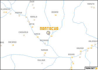
Nantácua (Cabo Delgado, Mozambique)Nantácua is a town in the Cabo Delgado region of Mozambique. An overview map of the region around Nantácua is displayed below.
regional and 3d topo map of Nantácua, Mozambique ::
Nantácua airports ::
The nearest airport is MZB - Mocimboa Da Praia, located 103.2 km north east of Nantácua.
Other airports nearby include POL - Pemba (143.2 km south east), MYW - Mtwara (192.4 km north), Nearby towns ::
Massomue (1.0km south east) //
Necamira (3.5km south west) //
Simica (4.4km west) //
Muadué (7.0km south) //
Untia (7.0km north west) //
Maguera (7.8km south) //
Napula (8.0km north west) //
Assane (8.1km north) //
Manhamba (9.0km north west) //
Mahunda (9.6km north west) //
Cahungo (10.9km north west) //
Assimo (12.1km south east) //
[all distances 'as the bird flies' and approximate]  Places with similar names to Nantácua, Mozambique ::
// Nantuk (MM)
// Ninhtauk (MM)
// Nandéké (CM)
// Niantic (US)
// Niantic (US)
// Nienadówka (PL)
// Niñodaguía (ES)
// Niñodaguía (ES)
// Niñodaguía (ES)
// Niantic (US)
Disclaimer :: Information on this page comes without warranty of any kind |
||
|
Where is Nantácua? Elevation and coordinates ::
Latitude (lat): 12°0'8"S Longitude (lon): 39°40'2"E
Elevation (approx.): 170m (map arrows pan, magnifying glasses zoom) |
||
|
Visiting Nantácua? Hotel/Accommodation ::
Book a hotel in Nantácua Travel Guide ::
Buy a travel guide for Mozambique rental cars ::
car rental offers GPS waypoint ::
download a GPX waypoint (PoI) of Nantácua for your GPS receiver
|
||