|
search place name
|
||
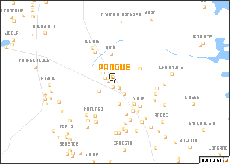
Pangue (Inhambane, Mozambique)Pangue is a town in the Inhambane region of Mozambique. An overview map of the region around Pangue is displayed below.
regional and 3d topo map of Pangue, Mozambique ::
Pangue airports ::
The nearest airport is VNX - Vilankulu Vilankulo, located 92.1 km south east of Pangue.
Other airports nearby include BEW - Beira (164.8 km north), Nearby towns ::
Chibaquele (0.9km south) //
Malandro (1.0km west) //
Pande (1.1km south east) //
Madomane (1.7km west) //
Mabongo (2.4km north west) //
Chefe Pande (2.4km south east) //
Mucheque (2.9km south west) //
Luís (3.6km south) //
Juga (4.5km north) //
João Tangue (4.4km north east) //
Mafumisse (4.7km south east) //
Laisse (5.5km south) //
Malanguene (5.5km south east) //
Dique (5.5km south east) //
Zate (5.7km north west) //
Matacate (6.0km south east) //
Matungo (6.4km south west) //
Rolane (6.5km north west) //
Régulo Machovo (6.7km south) //
Macoanhane (6.5km east) //
Gustavo (7.0km south) //
Meque (6.5km east) //
Chelene (6.8km south east) //
Afonso (7.0km south west) //
Taiela (7.1km south west) //
Amoco (7.6km south west) //
Pessecanhe (7.5km south east) //
João (7.8km south) //
Magine (7.7km south east) //
[all distances 'as the bird flies' and approximate]  Places with similar names to Pangue, Mozambique ::
Disclaimer :: Information on this page comes without warranty of any kind |
||
|
Where is Pangue? Elevation and coordinates ::
Latitude (lat): 21°17'6"S Longitude (lon): 34°53'34"E
Elevation (approx.): 45m (map arrows pan, magnifying glasses zoom) |
||
|
Visiting Pangue? Hotel/Accommodation ::
Book a hotel in Pangue Travel Guide ::
Buy a travel guide for Mozambique rental cars ::
car rental offers GPS waypoint ::
download a GPX waypoint (PoI) of Pangue for your GPS receiver
|
||