|
search place name
|
||
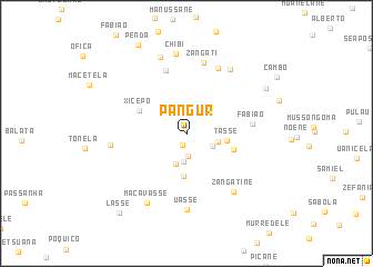
Pangur (Inhambane, Mozambique)Pangur is a town in the Inhambane region of Mozambique. An overview map of the region around Pangur is displayed below.
regional and 3d topo map of Pangur, Mozambique ::
Pangur airports ::
The nearest airport is VNX - Vilankulu Vilankulo, located 77.8 km north east of Pangur.
Other airports nearby include INH - Inhambane (154.9 km south), Nearby towns ::
Salemune (1.2km south) //
Camela (2.2km south) //
Manarro (2.8km south) //
Chipanela (2.7km south east) //
Satana (2.9km east) //
Muchichane (3.2km south) //
Tasse (3.8km east) //
Manhicane (4.2km south) //
Pagur (4.6km east) //
Xicepo (5.0km north west) //
Fabião (6.1km east) //
Janani (6.6km north) //
Filambo (7.1km north east) //
Zangati (7.3km north) //
Zangatine (7.2km south east) //
Uasse (7.6km south) //
Fabião (7.6km north east) //
Silvene (7.2km west) //
Maçavasse (7.8km south west) //
Chibi (8.0km north) //
Ernesto (8.1km north) //
Fernando (8.6km north east) //
Penda (10.0km north west) //
Lasse (10.1km south west) //
[all distances 'as the bird flies' and approximate]  Places with similar names to Pangur, Mozambique ::
// Pink Arrow (US)
// Pingree (US)
// Pancur (MY)
// Ponçarë (AL)
// Poiana Gruii (RO)
// Piñuécar (ES)
// Paengaroa (NZ)
// Paengaroa (NZ)
// Pongaroa (NZ)
// Pingree (US)
Disclaimer :: Information on this page comes without warranty of any kind |
||
|
Where is Pangur? Elevation and coordinates ::
Latitude (lat): 22°34'31"S Longitude (lon): 34°51'11"E
Elevation (approx.): 123m (map arrows pan, magnifying glasses zoom) |
||
|
Visiting Pangur? Hotel/Accommodation ::
Book a hotel in Pangur Travel Guide ::
Buy a travel guide for Mozambique rental cars ::
car rental offers GPS waypoint ::
download a GPX waypoint (PoI) of Pangur for your GPS receiver
|
||