|
search place name
|
||
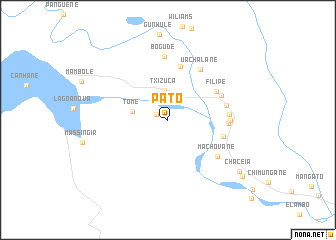
Pato (Gaza, Mozambique)Pato is a town in the Gaza region of Mozambique. An overview map of the region around Pato is displayed below.
regional and 3d topo map of Pato, Mozambique ::
Pato airports ::
The nearest airport is PHW - Phalaborwa, located 110.8 km west of Pato.
Other airports nearby include HDS - Hoedspruit Afb (132.2 km south west), SZK - Skukuza (135.4 km south west), LTA - Tzaneen (195.1 km west), Nearby towns ::
Marrenguele (1.3km north west) //
Chefe Chibotane (2.9km north east) //
Txizuca (3.3km north) //
Tomé (3.8km west) //
Mainzane (6.2km north) //
Filipe (5.9km north east) //
Escosse (5.9km east) //
Mabanda (6.1km north east) //
Uachalane (6.5km north east) //
Tohóbela (6.2km east) //
Madingâne (6.2km east) //
Machovane (6.5km south east) //
Chefe Matigane (6.3km east) //
Muôno (6.4km east) //
Bogude (7.1km north) //
Chaceia (9.3km south east) //
Macápa (9.9km south east) //
[all distances 'as the bird flies' and approximate]  Places with similar names to Pato, Mozambique ::
Disclaimer :: Information on this page comes without warranty of any kind |
||
|
Where is Pato? Elevation and coordinates ::
Latitude (lat): 23°53'42"S Longitude (lon): 32°14'35"E
Elevation (approx.): 93m (map arrows pan, magnifying glasses zoom) |
||
|
Visiting Pato? Hotel/Accommodation ::
Book a hotel in Pato Travel Guide ::
Buy a travel guide for Mozambique rental cars ::
car rental offers GPS waypoint ::
download a GPX waypoint (PoI) of Pato for your GPS receiver
|
||