|
search place name
|
||
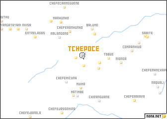
Tchepôce (Niassa, Mozambique)Tchepôce is a town in the Niassa region of Mozambique. An overview map of the region around Tchepôce is displayed below.
regional and 3d topo map of Tchepôce, Mozambique ::
Tchepôce airports ::
The nearest airport is BLZ - Blantyre Chileka Intl, located 130.0 km south west of Tchepôce.
Other airports nearby include VXC - Lichinga (208.9 km north), Nearby towns ::
Malângono (1.4km north) //
Tchalamanda (1.4km south) //
Chefe Chiposse (1.7km west) //
Chefe Cumulique (3.6km east) //
Uaite (3.9km south east) //
Tóbuè (5.5km east) //
Culimar (6.2km north east) //
Chefe Micuna (6.3km south west) //
Muima (6.5km south) //
Chefe Manhunho (7.0km north west) //
Balume (7.1km north) //
Malângono (7.2km north west) //
Matimbe (8.3km south) //
Chefe Quissacasse (8.4km south) //
Nionga (8.2km east) //
Manhunho (9.7km north west) //
Cuerócule (11.2km north west) //
[all distances 'as the bird flies' and approximate] 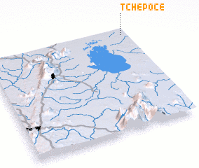 Places with similar names to Tchepôce, Mozambique ::
Disclaimer :: Information on this page comes without warranty of any kind |
||
|
Where is Tchepôce? Elevation and coordinates ::
Latitude (lat): 15°1'41"S Longitude (lon): 35°58'55"E
Elevation (approx.): 683m (map arrows pan, magnifying glasses zoom) |
||
|
Visiting Tchepôce? Hotel/Accommodation ::
Book a hotel in Tchepôce Travel Guide ::
Buy a travel guide for Mozambique rental cars ::
car rental offers GPS waypoint ::
download a GPX waypoint (PoI) of Tchepôce for your GPS receiver
|
||