|
search place name
|
||
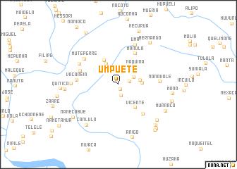
Umpuètê (Nampula, Mozambique)Umpuètê is a town in the Nampula region of Mozambique. An overview map of the region around Umpuètê is displayed below.
regional and 3d topo map of Umpuètê, Mozambique ::
Umpuètê airports ::
The nearest airport is APL - Nampula, located 90.2 km north of Umpuètê.
Other airports nearby include MNC - Nacala (206.0 km north east), Nearby towns ::
Joaquim (0.9km south east) //
Muamucha (1.8km south) //
Raque (1.8km east) //
Meta (2.2km north) //
Iapili (2.6km north east) //
Pilo (3.4km north east) //
Muitacale (3.4km east) //
Serepuíte (3.7km north west) //
Molote (3.6km east) //
Máquina (3.8km north east) //
Metita (4.4km north west) //
Vicente (4.5km south east) //
Mànula (5.5km north east) //
Sicome (6.0km south east) //
Fábula (6.2km west) //
Nanavale (6.3km east) //
Vacareia (6.4km west) //
Muteperre (6.6km north west) //
Uma (6.8km north) //
Mepèpula (6.7km north west) //
Ruaneque (7.2km west) //
Canlula (8.1km south west) //
Bernardo (8.2km north east) //
Mutaniquela (8.2km south east) //
Niquêta (8.2km west) //
Murraco (8.3km south east) //
Mana (8.4km east) //
Anigo (8.7km south) //
Cheveni (8.6km south east) //
[all distances 'as the bird flies' and approximate]  Places with similar names to Umpuètê, Mozambique ::
// Umpuata (MZ)
Disclaimer :: Information on this page comes without warranty of any kind |
||
|
Where is Umpuètê? Elevation and coordinates ::
Latitude (lat): 15°54'6"S Longitude (lon): 39°27'53"E
Elevation (approx.): 138m (map arrows pan, magnifying glasses zoom) |
||
|
Visiting Umpuètê? Hotel/Accommodation ::
Book a hotel in Umpuètê Travel Guide ::
Buy a travel guide for Mozambique rental cars ::
car rental offers GPS waypoint ::
download a GPX waypoint (PoI) of Umpuètê for your GPS receiver
|
||