|
search place name
|
||
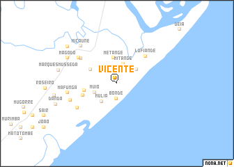
Vicente (Zambézia, Mozambique)Vicente is a town in the Zambézia region of Mozambique. An overview map of the region around Vicente is displayed below.
regional and 3d topo map of Vicente, Mozambique ::
Vicente airports ::
The nearest airport is UEL - Quelimane, located 54.3 km north of Vicente.
Other airports nearby include BEW - Beira (250.0 km south west), Nearby towns ::
Jamale (2.3km north) //
Bonde (2.4km south) //
Orcão (2.6km north east) //
Mitange (3.3km north) //
Mulia (3.7km south west) //
Matango (3.7km north east) //
Barra (3.7km north east) //
Muio (3.7km south west) //
Metange (4.1km north) //
Mussage (4.6km north west) //
Canuerde (4.6km north west) //
Arijuane (5.1km west) //
Poane (5.5km west) //
Lufiande (6.1km north east) //
Jacinto (6.9km north west) //
Jone (7.1km north west) //
Barco (7.2km south west) //
Arveira (7.6km west) //
Mafunga (7.7km west) //
Micaúne (8.2km north west) //
Magodo (8.6km north west) //
Magaza (9.6km north west) //
[all distances 'as the bird flies' and approximate] 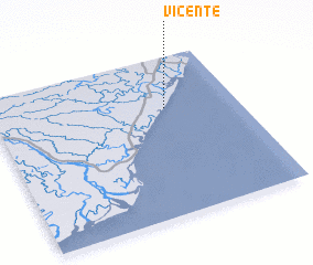 Places with similar names to Vicente, Mozambique ::
Disclaimer :: Information on this page comes without warranty of any kind |
||
|
Where is Vicente? Elevation and coordinates ::
Latitude (lat): 18°19'13"S Longitude (lon): 36°42'18"E
Elevation (approx.): 8m (map arrows pan, magnifying glasses zoom) |
||
|
Visiting Vicente? Hotel/Accommodation ::
Book a hotel in Vicente Travel Guide ::
Buy a travel guide for Mozambique rental cars ::
car rental offers GPS waypoint ::
download a GPX waypoint (PoI) of Vicente for your GPS receiver
|
||