|
search place name
|
||
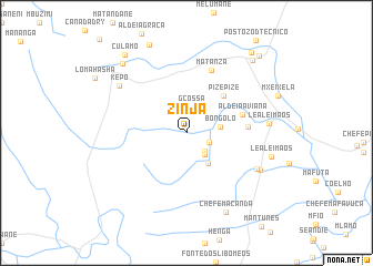
Zinja (Maputo, Mozambique)Zinja is a town in the Maputo region of Mozambique. An overview map of the region around Zinja is displayed below.
regional and 3d topo map of Zinja, Mozambique ::
Zinja airports ::
The nearest airport is MPM - Maputo, located 50.6 km east of Zinja.
Other airports nearby include MTS - Manzini Matsapha (95.0 km south west), SZK - Skukuza (128.8 km north west), HDS - Hoedspruit Afb (211.8 km north west), Nearby towns ::
Mocucuane (2.3km south east) //
Manhuenta (2.5km south east) //
G. Cossa (2.7km north) //
Uafana (2.7km south east) //
Bongolo (3.2km east) //
Santo (3.7km south east) //
Pizepize (5.0km north east) //
Bongolo (5.0km north east) //
Aldeia A. Viana (5.4km east) //
Canoca (5.6km east) //
Matanza (6.7km north) //
Mabesane (7.4km south east) //
Kepo (7.7km north west) //
Deda (7.6km south east) //
Leal e Imãos (7.5km east) //
Leal e Imãos (8.0km east) //
Chefe Macanda (8.7km south east) //
Namaacha (9.1km north west) //
M. Goncalves (9.5km north east) //
Culamo (9.6km north west) //
S. Rafael (10.0km north east) //
Diniz (10.1km north east) //
[all distances 'as the bird flies' and approximate] 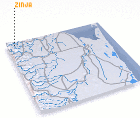 Places with similar names to Zinja, Mozambique ::
Disclaimer :: Information on this page comes without warranty of any kind |
||
|
Where is Zinja? Elevation and coordinates ::
Latitude (lat): 26°2'0"S Longitude (lon): 32°5'0"E
Elevation (approx.): 299m (map arrows pan, magnifying glasses zoom) |
||
|
Visiting Zinja? Hotel/Accommodation ::
Book a hotel in Zinja Travel Guide ::
Buy a travel guide for Mozambique rental cars ::
car rental offers GPS waypoint ::
download a GPX waypoint (PoI) of Zinja for your GPS receiver
|
||