|
search place name
|
||
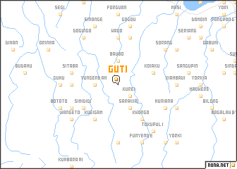
Guti (Papua New Guinea)Guti is a town in Papua New Guinea. An overview map of the region around Guti is displayed below.
regional and 3d topo map of Guti, Papua New Guinea ::
Guti airports ::
The nearest airport is MAG - Madang, located 69.9 km north west of Guti.
Other airports nearby include GKA - Goroka (97.3 km south west), LAE - Nadzab (113.4 km south east), HGU - Mount Hagen (209.5 km west), Nearby towns ::
Kurei (2.6km south east) //
Yungendam (3.7km west) //
Baubo (3.7km north) //
Sarakiri (4.1km south east) //
Koiaku (5.8km east) //
Simididi (6.7km south west) //
Kueigam (6.7km south west) //
Kwongo (6.7km south east) //
Karakara (7.4km west) //
Wado (7.4km north) //
Sitaba (7.6km west) //
Meibu (7.6km west) //
Basor (7.6km north) //
Ongo (8.3km south west) //
Muniana (8.3km south east) //
Wangeto (9.2km south west) //
Sakorila (9.2km south west) //
Dogingo (9.3km north west) //
Tukupuli (9.2km south east) //
Asang (9.2km north east) //
Sorang (9.2km north east) //
[all distances 'as the bird flies' and approximate] 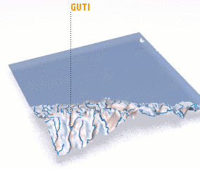 Places with similar names to Guti, Papua New Guinea ::
Disclaimer :: Information on this page comes without warranty of any kind |
||
|
Where is Guti? Elevation and coordinates ::
Latitude (lat): 5°42'0"S Longitude (lon): 146°11'0"E
Elevation (approx.): 951m (map arrows pan, magnifying glasses zoom) |
||
|
Visiting Guti? Hotel/Accommodation ::
Book a hotel in Guti Travel Guide ::
rental cars ::
car rental offers GPS waypoint ::
download a GPX waypoint (PoI) of Guti for your GPS receiver
|
||