|
search place name
|
||
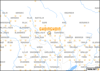
Gwoingwoin (Papua New Guinea)Gwoingwoin is a town in Papua New Guinea. An overview map of the region around Gwoingwoin is displayed below.
regional and 3d topo map of Gwoingwoin, Papua New Guinea ::
Gwoingwoin airports ::
The nearest airport is WWK - Wewak Intl, located 72.5 km east of Gwoingwoin.
Nearby towns ::
Milak (0.0km north) //
Wombak (1.8km east) //
Kukwal (1.8km east) //
Kulunge (1.9km north) //
Chiginambu (1.9km south) //
Apangai 2 (1.9km south) //
Saulik (1.9km north) //
Magapita (1.8km west) //
Bongiora (2.6km south east) //
Mainjok (2.6km south east) //
Maputma (2.6km north east) //
Misamgai (2.6km north west) //
Waikim (2.6km north west) //
Kuleligum (2.6km south west) //
Apangai 1 (2.6km south west) //
Kuminibis 2 (3.7km east) //
Balopwini (3.7km east) //
Yamelikum (3.7km west) //
Ami (3.7km west) //
Amahop 1 (3.7km west) //
Maprik 2 (4.1km south east) //
Nungalim (4.1km north west) //
Supa (4.1km north west) //
Sahali (4.1km north west) //
Kuminibis 1 (4.1km north east) //
Cheragum (4.1km south east) //
Amahop 2 (4.1km south west) //
Gweligum (4.1km south west) //
Maprik (5.2km south east) //
[all distances 'as the bird flies' and approximate] 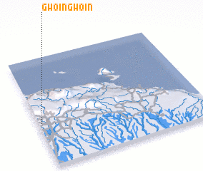 Places with similar names to Gwoingwoin, Papua New Guinea ::
// KwaNcwane (ZA)
// Kwankwanua (GH)
// Gwangwan (NG)
// Gwongwan (NG)
// Kwankwan (NG)
// Kwangwŏn-ni (KP)
// Cowan Cowan (AU)
// Gwongwana (CM)
Disclaimer :: Information on this page comes without warranty of any kind |
||
|
Where is Gwoingwoin? Elevation and coordinates ::
Latitude (lat): 3°36'0"S Longitude (lon): 143°1'0"E
Elevation (approx.): 218m (map arrows pan, magnifying glasses zoom) |
||
|
Visiting Gwoingwoin? Hotel/Accommodation ::
Book a hotel in Gwoingwoin Travel Guide ::
rental cars ::
car rental offers GPS waypoint ::
download a GPX waypoint (PoI) of Gwoingwoin for your GPS receiver
|
||