|
search place name
|
||
Iapoa (Papua New Guinea)Iapoa is a town in Papua New Guinea. An overview map of the region around Iapoa is displayed below.
regional and 3d topo map of Iapoa, Papua New Guinea ::
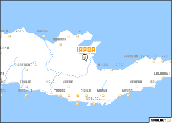
Nearby towns ::
Gomagamana (1.9km north) //
Aigubu (1.9km north) //
Iaviau (4.1km south east) //
Hiligoa (4.1km south east) //
Keia (5.9km north) //
Huhuna (5.8km east) //
Ginewa (6.6km north west) //
Waeme (6.6km south west) //
Awaiama (6.6km north west) //
Nigila (7.4km south) //
Gopia (7.6km south) //
Piori (7.5km east) //
Kidala (8.3km south west) //
Ahioma (8.3km south west) //
Duade (8.3km south east) //
Tinogo (9.2km south west) //
Kaloi (9.2km south west) //
Bubuleta (10.4km south east) //
[all distances 'as the bird flies' and approximate] 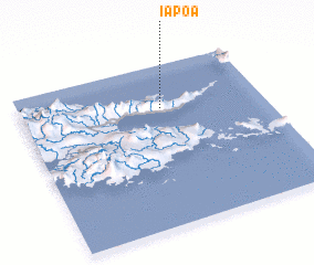 Places with similar names to Iapoa, Papua New Guinea ::
Disclaimer :: Information on this page comes without warranty of any kind |
||
|
Where is Iapoa? Elevation and coordinates ::
Latitude (lat): 10°16'0"S Longitude (lon): 150°35'0"E
Elevation (approx.): 23m (map arrows pan, magnifying glasses zoom) |
||
|
Visiting Iapoa? Hotel/Accommodation ::
Book a hotel in Iapoa Travel Guide ::
rental cars ::
car rental offers GPS waypoint ::
download a GPX waypoint (PoI) of Iapoa for your GPS receiver
|
||