|
search place name
|
||
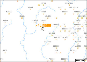
Kalingum (Sandaun, Papua New Guinea)Kalingum is a town in the Sandaun region of Papua New Guinea. An overview map of the region around Kalingum is displayed below.
regional and 3d topo map of Kalingum, Papua New Guinea ::
Kalingum airports ::
The nearest airport is DJJ - Jayapura Sentani, located 186.7 km north west of Kalingum.
Other airports nearby include WWK - Wewak Intl (193.2 km east), Nearby towns ::
Kwumtun (1.9km north) //
Yebil (1.9km north) //
Timeni (3.7km north) //
Wilkili (4.1km south east) //
Kuatim (5.2km north west) //
Twaitei (5.9km east) //
Urutei (5.9km north) //
Parisko (5.9km south) //
Tauwitei (6.7km south east) //
Kakoi (7.4km north) //
Lau'um (7.4km east) //
Buru'um (7.6km east) //
Eretei Number 2 (7.9km north east) //
Kamnum (9.3km south east) //
[all distances 'as the bird flies' and approximate]  Places with similar names to Kalingum, Papua New Guinea ::
// Klinkum (DE)
// Killingmo (NO)
// Kalınçam (TR)
// Kolonkoum (BF)
// Kalunkuma (CD)
// Kalunkumia (CD)
// Kaulungombe (CD)
// Kolonkema (CD)
// Kulangām (IN)
// Kaulinggam (ID)
Disclaimer :: Information on this page comes without warranty of any kind |
||
|
Where is Kalingum? Elevation and coordinates ::
Latitude (lat): 3°29'0"S Longitude (lon): 141°56'0"E
Elevation (approx.): 394m (map arrows pan, magnifying glasses zoom) |
||
|
Visiting Kalingum? Hotel/Accommodation ::
Book a hotel in Kalingum Travel Guide ::
rental cars ::
car rental offers GPS waypoint ::
download a GPX waypoint (PoI) of Kalingum for your GPS receiver
|
||