|
search place name
|
||
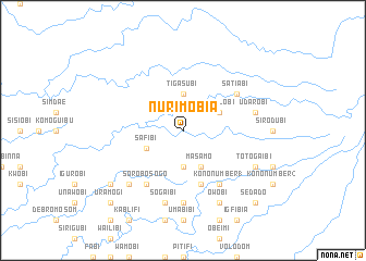
Nurimobia (Papua New Guinea)Nurimobia is a town in Papua New Guinea. An overview map of the region around Nurimobia is displayed below.
regional and 3d topo map of Nurimobia, Papua New Guinea ::
Nurimobia airports ::
The nearest airport is HGU - Mount Hagen, located 212.1 km east of Nurimobia.
Nearby towns ::
Kenagabobi (3.7km south) //
Tigasubi (3.7km north) //
Masamo (4.1km south east) //
Sefalobi (4.1km north east) //
Safibi (4.1km south west) //
Ianowabi (5.9km south) //
Satiabi (6.7km north east) //
Kono Number 1 (6.7km south east) //
Halimobi (6.7km south west) //
Sorobosogo (6.7km south west) //
Bosabi (7.4km south) //
Bubusamabi (7.4km south) //
Udarobi (7.6km east) //
Sagami (7.6km south) //
Sogaibi (7.6km south) //
Kodolombia (7.8km south west) //
Tegomidibi (8.2km south east) //
Totogaibi (8.2km south east) //
Owobi (8.3km south east) //
Misuebi (9.2km south west) //
Sedado (10.5km south east) //
Uramogi (10.5km south west) //
[all distances 'as the bird flies' and approximate] 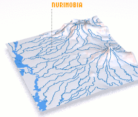 Places with similar names to Nurimobia, Papua New Guinea :: Disclaimer :: Information on this page comes without warranty of any kind |
||
|
Where is Nurimobia? Elevation and coordinates ::
Latitude (lat): 6°12'0"S Longitude (lon): 142°25'0"E
Elevation (approx.): 245m (map arrows pan, magnifying glasses zoom) |
||
|
Visiting Nurimobia? Hotel/Accommodation ::
Book a hotel in Nurimobia Travel Guide ::
rental cars ::
car rental offers GPS waypoint ::
download a GPX waypoint (PoI) of Nurimobia for your GPS receiver
|
||