|
search place name
|
||
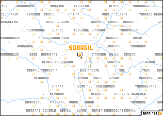
Sobagil (Papua New Guinea)Sobagil is a town in Papua New Guinea. An overview map of the region around Sobagil is displayed below.
regional and 3d topo map of Sobagil, Papua New Guinea ::
Sobagil airports ::
The nearest airport is GKA - Goroka, located 50.8 km east of Sobagil.
Other airports nearby include HGU - Mount Hagen (75.4 km west), MAG - Madang (134.2 km north east), LAE - Nadzab (206.0 km east), Nearby towns ::
Bianggau (0.0km north) //
Kulekane (1.9km north) //
Walegau (1.8km east) //
Kobokane (2.6km south west) //
Naurunggauma (2.6km south west) //
Kwiamkane Number 1 (2.6km north west) //
Bemal (2.6km south east) //
Elukane (2.6km south east) //
Nuilgauma (2.6km north east) //
Korokoa (2.6km north east) //
Balgauma (3.7km west) //
Kalumbianggo (3.7km south) //
Mainakoru (3.7km east) //
Genabona (4.1km south west) //
Kebamiankani (4.1km south west) //
Barekane (4.1km north west) //
Elamkane (4.1km north west) //
Silbianggau (4.1km south east) //
Simegu (4.1km north east) //
Digakane Number 1 (4.1km north east) //
Damadumane (4.1km north east) //
Kombukane (5.2km north west) //
Naru (5.2km north west) //
Mornmaul (5.6km south) //
Toglkane (5.6km north) //
Kunaunaku (5.5km east) //
Sigauga (5.9km north) //
Kamalakane (5.8km east) //
Kumbianggau (5.8km east) //
[all distances 'as the bird flies' and approximate]  Places with similar names to Sobagil, Papua New Guinea ::
Disclaimer :: Information on this page comes without warranty of any kind |
||
|
Where is Sobagil? Elevation and coordinates ::
Latitude (lat): 6°4'0"S Longitude (lon): 144°56'0"E
Elevation (approx.): 2113m (map arrows pan, magnifying glasses zoom) |
||
|
Visiting Sobagil? Hotel/Accommodation ::
Book a hotel in Sobagil Travel Guide ::
rental cars ::
car rental offers GPS waypoint ::
download a GPX waypoint (PoI) of Sobagil for your GPS receiver
|
||