|
search place name
|
||
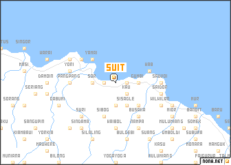
Suit (Papua New Guinea)Suit is a town in Papua New Guinea. An overview map of the region around Suit is displayed below.
regional and 3d topo map of Suit, Papua New Guinea ::
Suit airports ::
The nearest airport is MAG - Madang, located 81.5 km north west of Suit.
Other airports nearby include LAE - Nadzab (111.4 km south), GKA - Goroka (122.9 km south west), Nearby towns ::
Yauniai (1.8km east) //
Galek (1.8km west) //
Yeimas (1.8km east) //
Kau (2.6km south east) //
Gumbi (3.7km east) //
Awun (3.7km south) //
Sor (3.7km west) //
Sisagle (4.1km south east) //
Lapun (5.2km south east) //
Yamai (5.2km north west) //
Wab (5.8km east) //
Sibog (5.9km south) //
Busaka (6.7km south east) //
Teterei (6.7km north west) //
Waibol (7.4km south) //
Sauvoi (7.4km east) //
Pang Pang (7.4km west) //
Saidor (7.6km east) //
Yori (7.6km west) //
Suri (7.8km south west) //
Nampa (8.3km south east) //
Wilwilan (8.3km south east) //
Kalalin (8.3km south east) //
Biliau Mission (8.3km north west) //
Sindama (9.3km south west) //
Aiyawa (10.5km south west) //
[all distances 'as the bird flies' and approximate] 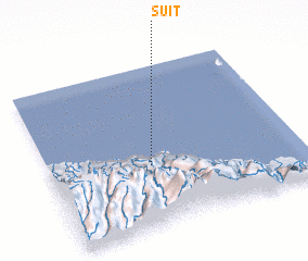 Places with similar names to Suit, Papua New Guinea ::
Disclaimer :: Information on this page comes without warranty of any kind |
||
|
Where is Suit? Elevation and coordinates ::
Latitude (lat): 5°37'0"S Longitude (lon): 146°24'0"E
Elevation (approx.): -32768m (map arrows pan, magnifying glasses zoom) |
||
|
Visiting Suit? Hotel/Accommodation ::
Book a hotel in Suit Travel Guide ::
rental cars ::
car rental offers GPS waypoint ::
download a GPX waypoint (PoI) of Suit for your GPS receiver
|
||