|
search place name
|
||
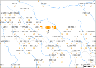
Tumamba (Papua New Guinea)Tumamba is a town in Papua New Guinea. An overview map of the region around Tumamba is displayed below.
regional and 3d topo map of Tumamba, Papua New Guinea ::
Tumamba airports ::
The nearest airport is WWK - Wewak Intl, located 92.9 km east of Tumamba.
Nearby towns ::
Pelnandu (2.6km south west) //
Bengil (2.6km north east) //
Arisili (2.6km north east) //
Asiling (3.7km west) //
Misim (4.1km south west) //
Whalen (4.1km north west) //
Samisai (4.1km south west) //
Selnau (4.1km north east) //
Selni (4.1km north east) //
Warengame (4.1km south east) //
Sumul (5.2km north west) //
Morang (5.2km south west) //
Wareli Villages (5.2km south east) //
Perembil (5.5km west) //
Alumi (5.6km south) //
Emul (5.6km south) //
Hambini (5.5km east) //
Selni (5.5km east) //
Musenau (5.9km west) //
Mamaisum (5.9km west) //
Luwaite Villages (5.9km south) //
Bana (5.9km east) //
Sahik (6.7km north west) //
Wamsak 1 (7.4km east) //
Yalangel (7.6km west) //
Yambes (7.6km west) //
Bonahoi (7.6km south) //
Sarom (7.6km south) //
Aman (7.6km east) //
[all distances 'as the bird flies' and approximate] 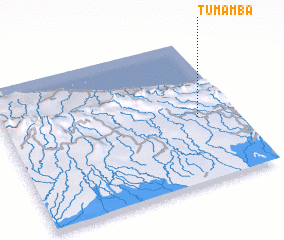 Places with similar names to Tumamba, Papua New Guinea ::
Disclaimer :: Information on this page comes without warranty of any kind |
||
|
Where is Tumamba? Elevation and coordinates ::
Latitude (lat): 3°33'0"S Longitude (lon): 142°50'0"E
Elevation (approx.): 378m (map arrows pan, magnifying glasses zoom) |
||
|
Visiting Tumamba? Hotel/Accommodation ::
Book a hotel in Tumamba Travel Guide ::
rental cars ::
car rental offers GPS waypoint ::
download a GPX waypoint (PoI) of Tumamba for your GPS receiver
|
||