|
search place name
|
||
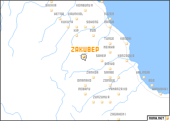
Zakubep (Papua New Guinea)Zakubep is a town in Papua New Guinea. An overview map of the region around Zakubep is displayed below.
regional and 3d topo map of Zakubep, Papua New Guinea ::
Zakubep airports ::
The nearest airport is LAE - Nadzab, located 102.5 km south west of Zakubep.
Other airports nearby include MAG - Madang (228.0 km north west), Nearby towns ::
Samep (3.7km east) //
Gerup (3.7km east) //
Zankoa (4.1km south east) //
Orarako (5.6km south) //
Kip (5.9km north) //
Ririwo (5.8km east) //
Rua (5.9km north) //
Meiawa (5.8km east) //
Sambe (6.7km south east) //
Tunge (6.7km north east) //
Rebafu (7.4km south) //
Bakon (7.4km north) //
Biuingen (7.6km north) //
Soweng (7.6km north) //
Zoroge (7.8km south east) //
Kukuya (8.3km north west) //
Hudewa (8.2km south east) //
Nanda (9.2km north east) //
Yamanzako (10.5km south east) //
[all distances 'as the bird flies' and approximate] 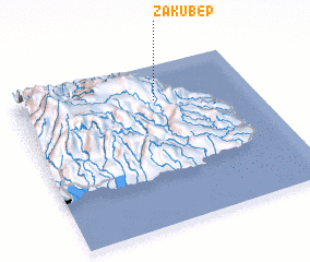 Places with similar names to Zakubep, Papua New Guinea :: Disclaimer :: Information on this page comes without warranty of any kind |
||
|
Where is Zakubep? Elevation and coordinates ::
Latitude (lat): 6°13'0"S Longitude (lon): 147°35'0"E
Elevation (approx.): 1738m (map arrows pan, magnifying glasses zoom) |
||
|
Visiting Zakubep? Hotel/Accommodation ::
Book a hotel in Zakubep Travel Guide ::
rental cars ::
car rental offers GPS waypoint ::
download a GPX waypoint (PoI) of Zakubep for your GPS receiver
|
||