|
search place name
|
||
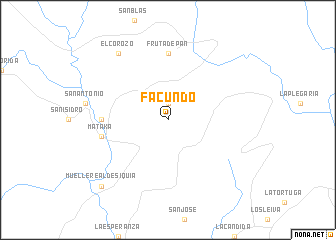
Facundo (Región Autónoma Atlántico Sur, Nicaragua)Facundo is a town in the Región Autónoma Atlántico Sur region of Nicaragua. An overview map of the region around Facundo is displayed below.
regional and 3d topo map of Facundo, Nicaragua ::
Facundo airports ::
The nearest airport is BEF - Bluefields, located 61.6 km south east of Facundo.
Other airports nearby include MGA - Managua Intl (211.4 km west), PUZ - Puerto Cabezas (212.3 km north east), LIR - Liberia Daniel Oduber Quiros Intl (238.3 km south west), Nearby towns ::
Clemente Canales (1.9km north) //
Fruta de Pan (7.4km north) //
Las Nubes (7.2km west) //
Mataka (7.5km west) //
El Corozo (9.2km north west) //
Muelle Real de Siquia (10.4km south west) //
[all distances 'as the bird flies' and approximate] 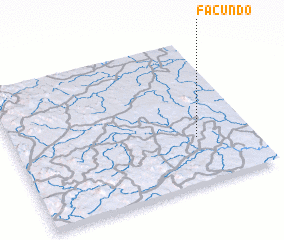 Places with similar names to Facundo, Nicaragua ::
Disclaimer :: Information on this page comes without warranty of any kind |
||
|
Where is Facundo? Elevation and coordinates ::
Latitude (lat): 12°19'0"N Longitude (lon): 84°14'0"W
Elevation (approx.): 116m (map arrows pan, magnifying glasses zoom) |
||
|
Visiting Facundo? Hotel/Accommodation ::
Book a hotel in Facundo Travel Guide ::
Buy a travel guide for Nicaragua rental cars ::
car rental offers GPS waypoint ::
download a GPX waypoint (PoI) of Facundo for your GPS receiver
|
||