|
search place name
|
||
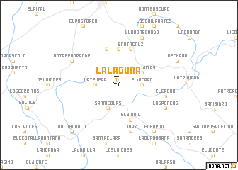
La Laguna (León, Nicaragua)La Laguna is a town in the León region of Nicaragua. An overview map of the region around La Laguna is displayed below.
regional and 3d topo map of La Laguna, Nicaragua ::
La Laguna airports ::
The nearest airport is MGA - Managua Intl, located 93.0 km south of La Laguna.
Other airports nearby include TGU - Tegucigalpa Toncontin Intl (154.3 km north west), Nearby towns ::
Las Camaras (2.6km north east) //
El Jícaro (3.6km east) //
La Tejera (3.6km west) //
San Nicolás (4.1km south west) //
Las Lajitas (4.1km north east) //
El Ocotillo (5.6km north) //
El Barro (5.8km south) //
Santa Cruz (5.8km north) //
Estanzuela (5.8km north) //
El Cacao (7.5km east) //
Limay (7.6km south) //
Llano Redondo (8.2km north east) //
Las Pencas (8.1km south east) //
Potrero Grande (8.1km north west) //
El Horno (9.2km south east) //
Palo Blanco (10.4km south west) //
[all distances 'as the bird flies' and approximate] 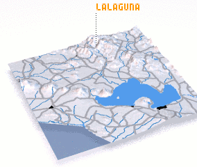 Places with similar names to La Laguna, Nicaragua ::
Disclaimer :: Information on this page comes without warranty of any kind |
||
|
Where is La Laguna? Elevation and coordinates ::
Latitude (lat): 12°58'0"N Longitude (lon): 86°20'0"W
Elevation (approx.): 1252m (map arrows pan, magnifying glasses zoom) |
||
|
Visiting La Laguna? Hotel/Accommodation ::
Book a hotel in La Laguna Travel Guide ::
Buy a travel guide for Nicaragua rental cars ::
car rental offers GPS waypoint ::
download a GPX waypoint (PoI) of La Laguna for your GPS receiver
|
||