|
search place name
|
||
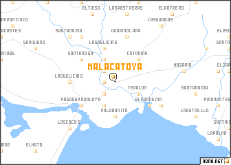
Malacatoya (Granada, Nicaragua)Malacatoya is a town in the Granada region of Nicaragua. An overview map of the region around Malacatoya is displayed below.
regional and 3d topo map of Malacatoya, Nicaragua ::
Malacatoya airports ::
The nearest airport is MGA - Managua Intl, located 36.5 km west of Malacatoya.
Other airports nearby include LIR - Liberia Daniel Oduber Quiros Intl (175.1 km south), TGU - Tegucigalpa Toncontin Intl (259.2 km north west), Nearby towns ::
Los Puentes (1.8km west) //
La Virgen (2.6km south west) //
San Fernando (2.6km north west) //
La Concepción (4.1km north west) //
La Esperanza (4.1km south west) //
Tepalón (4.1km south east) //
Catarina (5.2km north east) //
Palo Bonito (5.6km south) //
Las Delicias (5.8km north) //
Santa Rosa (6.6km north west) //
Paso de Panaloya (6.6km south west) //
El Porvenir (6.6km south east) //
Las Delicias (7.2km west) //
Guapinolapa (7.6km north) //
Alta Mira (8.1km south east) //
San Ramón (9.2km north west) //
Santa María (10.4km north west) //
Los Cocos (10.4km south west) //
[all distances 'as the bird flies' and approximate] 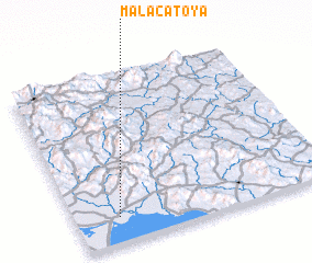 Places with similar names to Malacatoya, Nicaragua ::
// Malacatoya (NI)
// Malākidīyah (YE)
Disclaimer :: Information on this page comes without warranty of any kind |
||
|
Where is Malacatoya? Elevation and coordinates ::
Latitude (lat): 12°9'0"N Longitude (lon): 85°50'0"W
Elevation (approx.): 40m (map arrows pan, magnifying glasses zoom) |
||
|
Visiting Malacatoya? Hotel/Accommodation ::
Book a hotel in Malacatoya Travel Guide ::
Buy a travel guide for Nicaragua rental cars ::
car rental offers GPS waypoint ::
download a GPX waypoint (PoI) of Malacatoya for your GPS receiver
|
||