|
search place name
|
||
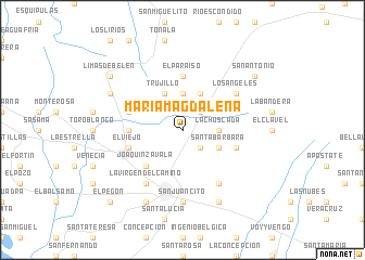
María Magdalena (Chinandega, Nicaragua)María Magdalena is a town in the Chinandega region of Nicaragua. An overview map of the region around María Magdalena is displayed below.
regional and 3d topo map of María Magdalena, Nicaragua ::
María Magdalena airports ::
The nearest airport is MGA - Managua Intl, located 119.3 km south east of María Magdalena.
Other airports nearby include TGU - Tegucigalpa Toncontin Intl (152.8 km north), SAL - San Salvador El Salvador Intl (226.4 km west), Nearby towns ::
San Ubaldo (2.6km south east) //
San Pedro (2.6km north east) //
La Chuscada (3.6km east) //
San José (3.7km north) //
Los Reyes (4.1km south east) //
Santa Bárbara (4.1km south east) //
Trujillo (4.1km north west) //
Sabana Grande (4.1km north east) //
Joaquín Zavala (5.2km south west) //
Los Ángeles (5.4km west) //
El Paraíso (5.6km north) //
El Viejo (5.7km west) //
El Pellisco (5.7km east) //
La República (5.7km west) //
La Gaveta (6.6km south west) //
La Virgen del Camino (6.6km south west) //
Las Cuatro Esquinas de la Mora (6.6km south east) //
Los Ángeles (6.6km north east) //
San Juancito (7.4km south) //
Chinandega (8.2km south west) //
Mérida (8.2km south east) //
San José de Cuasompa (8.1km north west) //
Limas de Belén (9.1km north west) //
San Antonio (9.1km north east) //
El Pegón (10.4km south west) //
[all distances 'as the bird flies' and approximate] 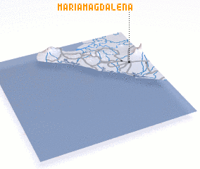 Places with similar names to María Magdalena, Nicaragua ::
Disclaimer :: Information on this page comes without warranty of any kind |
||
|
Where is María Magdalena? Elevation and coordinates ::
Latitude (lat): 12°41'0"N Longitude (lon): 87°7'0"W
Elevation (approx.): 126m (map arrows pan, magnifying glasses zoom) |
||
|
Visiting María Magdalena? Hotel/Accommodation ::
Book a hotel in María Magdalena Travel Guide ::
Buy a travel guide for Nicaragua rental cars ::
car rental offers GPS waypoint ::
download a GPX waypoint (PoI) of María Magdalena for your GPS receiver
|
||