|
search place name
|
||
Mina Verde (Matagalpa, Nicaragua)Mina Verde is a town in the Matagalpa region of Nicaragua. An overview map of the region around Mina Verde is displayed below.
regional and 3d topo map of Mina Verde, Nicaragua ::

Mina Verde airports ::
The nearest airport is MGA - Managua Intl, located 88.9 km south west of Mina Verde.
Other airports nearby include TGU - Tegucigalpa Toncontin Intl (201.1 km north west), Nearby towns ::
La Caldera (0.0km north) //
Guadalupe (2.6km north west) //
El Chile (3.7km south) //
Samulali (5.4km west) //
El Naranjo (5.6km north) //
La Reina (5.6km north) //
San Pablo (5.7km east) //
San Ramón (5.8km north) //
Susuli (6.6km south west) //
Laguna Seca (6.6km south east) //
La Leonesa (7.6km north) //
Santa Rita (7.5km west) //
Las Ánimas (7.6km south) //
La China (7.8km north west) //
Piedra Colorada (8.1km south west) //
La Garita (9.2km north west) //
La Esperanza (9.1km south east) //
La Cuesta de Apatite (9.1km south east) //
El Zarzal (10.4km south west) //
[all distances 'as the bird flies' and approximate] 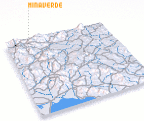 Places with similar names to Mina Verde, Nicaragua ::
Disclaimer :: Information on this page comes without warranty of any kind |
||
|
Where is Mina Verde? Elevation and coordinates ::
Latitude (lat): 12°52'0"N Longitude (lon): 85°49'0"W
Elevation (approx.): 539m (map arrows pan, magnifying glasses zoom) |
||
|
Visiting Mina Verde? Hotel/Accommodation ::
Book a hotel in Mina Verde Travel Guide ::
Buy a travel guide for Nicaragua rental cars ::
car rental offers GPS waypoint ::
download a GPX waypoint (PoI) of Mina Verde for your GPS receiver
|
||