|
search place name
|
||
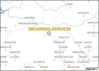
San Juan de Las Pencas (Chinandega, Nicaragua)San Juan de Las Pencas is a town in the Chinandega region of Nicaragua. An overview map of the region around San Juan de Las Pencas is displayed below.
regional and 3d topo map of San Juan de Las Pencas, Nicaragua ::
San Juan de Las Pencas airports ::
The nearest airport is MGA - Managua Intl, located 106.8 km south east of San Juan de Las Pencas.
Other airports nearby include TGU - Tegucigalpa Toncontin Intl (146.8 km north), Nearby towns ::
Candelaria (1.9km north) //
Santa Ernestina (1.8km west) //
Alsacia (2.6km south east) //
Villa Quince de Julio (4.0km north west) //
Las Grietas (5.2km south east) //
Talpetate (5.7km east) //
El Obraje (6.6km north west) //
El Higueral (6.6km south east) //
El Zapote (7.5km west) //
Olomega (7.8km south east) //
La Española (8.2km south east) //
San Lucas (8.2km south east) //
San José del Obraje (8.4km north west) //
La Polvosa (9.1km north west) //
[all distances 'as the bird flies' and approximate] 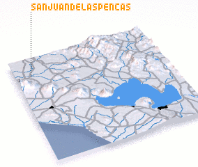 Places with similar names to San Juan de Las Pencas, Nicaragua :: Disclaimer :: Information on this page comes without warranty of any kind |
||
|
Where is San Juan de Las Pencas? Elevation and coordinates ::
Latitude (lat): 12°46'0"N Longitude (lon): 86°55'0"W
Elevation (approx.): 41m (map arrows pan, magnifying glasses zoom) |
||
|
Visiting San Juan de Las Pencas? Hotel/Accommodation ::
Book a hotel in San Juan de Las Pencas Travel Guide ::
Buy a travel guide for Nicaragua rental cars ::
car rental offers GPS waypoint ::
download a GPX waypoint (PoI) of San Juan de Las Pencas for your GPS receiver
|
||