|
search place name
|
||
Baloole (Bay, Somalia)Baloole is a town in the Bay region of Somalia. An overview map of the region around Baloole is displayed below.
regional and 3d topo map of Baloole, Somalia ::
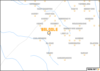
Nearby towns ::
Dheenka (2.6km north west) //
Ailesho (3.7km south) //
Reebbay (4.1km north east) //
Gallool (4.1km north east) //
Ceel Masaare (4.1km south west) //
Reebbay (5.2km north east) //
Kashid (5.2km north west) //
Libayle (5.6km east) //
Garba Dheer (5.6km east) //
Galoollo (5.9km north) //
Kuunya Dheetle (5.9km north) //
Ikirray (5.9km north) //
Yuubka (5.9km east) //
Beled Amiin (7.4km east) //
Caday Kud (7.4km north) //
Sodori (7.4km south) //
Aabaan Yare (7.6km east) //
Golol Dheere (7.6km east) //
Caday Kud (7.6km north) //
Aabaan Weyn (7.9km north east) //
Ikirray (9.3km north west) //
[all distances 'as the bird flies' and approximate]  Places with similar names to Baloole, Somalia ::
Disclaimer :: Information on this page comes without warranty of any kind |
||
|
Where is Baloole? Elevation and coordinates ::
Latitude (lat): 2°36'0"N Longitude (lon): 43°58'0"E
Elevation (approx.): 182m (map arrows pan, magnifying glasses zoom) |
||
|
Visiting Baloole? Hotel/Accommodation ::
Book a hotel in Baloole Travel Guide ::
Buy a travel guide for Somalia rental cars ::
car rental offers GPS waypoint ::
download a GPX waypoint (PoI) of Baloole for your GPS receiver
|
||