|
search place name
|
||
Cananoola (Bay, Somalia)Cananoola is a town in the Bay region of Somalia. An overview map of the region around Cananoola is displayed below.
regional and 3d topo map of Cananoola, Somalia ::
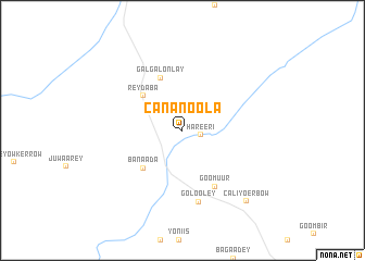
Nearby towns ::
Hareeri (2.0km east) //
Reydaba (5.4km north west) //
Banaada (5.6km south west) //
Gal Gal Onlay (5.8km north) //
Goomuur (6.7km south east) //
Golooley (7.5km south) //
Caliyo Erbow (9.8km south east) //
[all distances 'as the bird flies' and approximate] 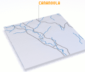 Places with similar names to Cananoola, Somalia ::
// Ganiniel (SN)
// Kanène Al (SN)
// Gonānlū (IR)
// Qūynānlū (IR)
// Kan‘ān-e Īl (IR)
// Kānī ‘Eyn ‘Alī (IR)
// Qūʼīnānlū (IR)
// Gonanala (LR)
// Qiannianli (CN)
// Cononley (GB)
Disclaimer :: Information on this page comes without warranty of any kind |
||
|
Where is Cananoola? Elevation and coordinates ::
Latitude (lat): 1°56'5"N Longitude (lon): 42°36'11"E
Elevation (approx.): 159m (map arrows pan, magnifying glasses zoom) |
||
|
Visiting Cananoola? Hotel/Accommodation ::
Book a hotel in Cananoola Travel Guide ::
Buy a travel guide for Somalia rental cars ::
car rental offers GPS waypoint ::
download a GPX waypoint (PoI) of Cananoola for your GPS receiver
|
||