|
search place name
|
||
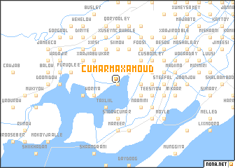
Cumar Maxamoud (Shabeellaha Hoose, Somalia)Cumar Maxamoud is a town in the Shabeellaha Hoose region of Somalia. An overview map of the region around Cumar Maxamoud is displayed below.
regional and 3d topo map of Cumar Maxamoud, Somalia ::
Nearby towns ::
Dunaati (0.0km north) //
Siisab (0.0km north) //
Shariif Jeeylaani (2.6km north east) //
Xaaji Faarax (2.6km north east) //
Maduulow (3.7km east) //
Taxliil (4.1km south west) //
Jeerrow (4.1km south west) //
Jorje (4.1km south west) //
Cabdi Uqaabi (4.1km south west) //
Woriya (4.1km south west) //
Raaxoole (4.1km south east) //
Musa Cilmi (4.1km south east) //
Xaaji Abuukar (5.2km north west) //
Caanooley ”B” (5.2km north west) //
Naanini (5.2km south east) //
Axmed Guure (5.2km north east) //
Siiba (5.6km east) //
Siidow Cumar (5.6km south) //
Far Xaano (5.6km north) //
Siimow (5.6km north) //
Shiikh (5.9km north) //
Buraale (5.9km north) //
Teesiyow (5.9km east) //
Barde Saalax (5.9km east) //
Shiikh (5.9km north) //
Madow (5.9km north) //
Aboow Cali (5.9km north) //
Canalow (5.9km west) //
Golweyn (6.7km south east) //
[all distances 'as the bird flies' and approximate]  Places with similar names to Cumar Maxamoud, Somalia :: Disclaimer :: Information on this page comes without warranty of any kind |
||
|
Where is Cumar Maxamoud? Elevation and coordinates ::
Latitude (lat): 1°42'0"N Longitude (lon): 44°32'0"E
Elevation (approx.): 67m (map arrows pan, magnifying glasses zoom) |
||
|
Visiting Cumar Maxamoud? Hotel/Accommodation ::
Book a hotel in Cumar Maxamoud Travel Guide ::
Buy a travel guide for Somalia rental cars ::
car rental offers GPS waypoint ::
download a GPX waypoint (PoI) of Cumar Maxamoud for your GPS receiver
|
||