|
search place name
|
||
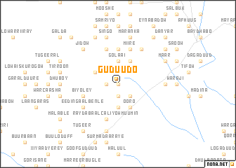
Guduudo (Bay, Somalia)Guduudo is a town in the Bay region of Somalia. An overview map of the region around Guduudo is displayed below.
regional and 3d topo map of Guduudo, Somalia ::
Nearby towns ::
Gurtimaley (0.0km north) //
Ubor Uuma (1.9km west) //
Gommarey (1.9km north) //
Gorer Weyn (1.9km south) //
Miidaay (1.9km south) //
Galoshe (2.6km north east) //
Deg Gonay (2.6km south east) //
Oodan (3.7km south) //
Dambale (3.7km south) //
Golaai (3.7km north) //
Ooro (4.1km south east) //
Ashagow (4.1km north east) //
Aroos Ibir (4.1km north east) //
Aabarak (4.1km north west) //
Luga Dheere (5.6km north) //
Osboola (5.9km south) //
Raydabaal Caliyow Muumin (5.9km south) //
Hooday (5.9km south) //
Caddi Qoqonay (5.9km north) //
Miire (5.9km north) //
Gamarey (5.9km north) //
Biyoley (5.9km west) //
Abdurug (6.7km south west) //
Eedin Gaal Benle (6.7km south west) //
Hare (6.7km north east) //
Dadjenai (7.4km east) //
Caliyow Muumin (7.6km south) //
Singo (7.6km north) //
Malaag (7.6km north) //
[all distances 'as the bird flies' and approximate] 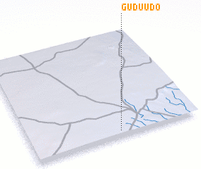 Places with similar names to Guduudo, Somalia ::
Disclaimer :: Information on this page comes without warranty of any kind |
||
|
Where is Guduudo? Elevation and coordinates ::
Latitude (lat): 3°3'0"N Longitude (lon): 43°32'0"E
Elevation (approx.): 474m (map arrows pan, magnifying glasses zoom) |
||
|
Visiting Guduudo? Hotel/Accommodation ::
Book a hotel in Guduudo Travel Guide ::
Buy a travel guide for Somalia rental cars ::
car rental offers GPS waypoint ::
download a GPX waypoint (PoI) of Guduudo for your GPS receiver
|
||