|
search place name
|
||
Soohane (Shabeellaha Hoose, Somalia)Soohane is a town in the Shabeellaha Hoose region of Somalia. An overview map of the region around Soohane is displayed below.
regional and 3d topo map of Soohane, Somalia ::
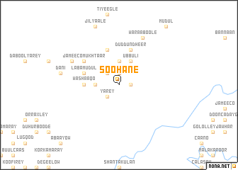
Nearby towns ::
Walburre (1.9km north) //
Garasley (1.9km east) //
Bisiqley (2.6km north west) //
Yarey (2.6km south west) //
Dood (2.6km south west) //
Joofley (3.7km north) //
Dhaxanley (3.7km west) //
Ubbuli (4.1km north east) //
Washaaqo (5.6km west) //
Abeesaale (5.6km west) //
Baalley (5.9km north) //
Cadaley (5.9km north) //
Labamudul (5.9km west) //
Garas Guudle (5.9km west) //
Duddun Dheer (5.9km north) //
Garascad (6.7km north west) //
Jameeco Mukhtaar (6.7km north west) //
Garas Moqorrey (8.3km north west) //
Waraaboole (8.3km north east) //
[all distances 'as the bird flies' and approximate] 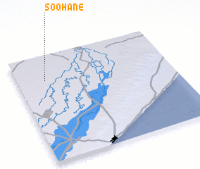 Places with similar names to Soohane, Somalia ::
Disclaimer :: Information on this page comes without warranty of any kind |
||
|
Where is Soohane? Elevation and coordinates ::
Latitude (lat): 2°46'0"N Longitude (lon): 45°11'0"E
Elevation (approx.): 98m (map arrows pan, magnifying glasses zoom) |
||
|
Visiting Soohane? Hotel/Accommodation ::
Book a hotel in Soohane Travel Guide ::
Buy a travel guide for Somalia rental cars ::
car rental offers GPS waypoint ::
download a GPX waypoint (PoI) of Soohane for your GPS receiver
|
||