|
search place name
|
||
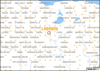
Lhomond (Sud, Haiti)Lhomond is a town in the Sud region of Haiti. An overview map of the region around Lhomond is displayed below.
regional and 3d topo map of Lhomond, Haiti ::
Lhomond airports ::
The nearest airport is PAP - Port-au-prince Toussaint Louverture Intl, located 87.3 km east of Lhomond.
Other airports nearby include CAP - Cap Haitien Intl (179.4 km north east), BRX - Barahona Maria Montez Intl (207.8 km east), Nearby towns ::
Nan Bourrique (0.0km north) //
Laurier (1.8km east) //
Latour (1.8km west) //
Grande Place (1.8km west) //
Boco (1.9km north) //
Morency (1.9km south) //
Ménard (2.6km north east) //
Mamezelle (2.6km north east) //
Beaudouin (2.6km south east) //
Fréneau (2.6km south east) //
Haut du Four (3.7km north) //
Tazac (3.5km east) //
Morne Canne (3.5km east) //
Jeanette (3.5km east) //
Corail (3.5km west) //
Grande Caille (3.5km west) //
Yvon (4.1km north east) //
Carrefour Moussignac (4.1km north west) //
Godet (4.1km south west) //
Saint-Michel du Sud (4.0km north west) //
Bassin Bleu (4.0km north west) //
Colombel (5.1km north east) //
Chérési (5.1km north west) //
Pilaurant (5.1km south west) //
Caroline (5.3km west) //
Morne à Brûler (5.6km south) //
Jules (5.3km east) //
Petite Colline (5.3km east) //
Saint-Martin (5.8km north) //
[all distances 'as the bird flies' and approximate] 
Disclaimer :: Information on this page comes without warranty of any kind |
||
|
Where is Lhomond? Elevation and coordinates ::
Latitude (lat): 18°21'0"N Longitude (lon): 73°5'0"W
Elevation (approx.): 292m (map arrows pan, magnifying glasses zoom) |
||
|
Visiting Lhomond? Hotel/Accommodation ::
Book a hotel in Lhomond Travel Guide ::
Buy a travel guide for Haiti rental cars ::
car rental offers GPS waypoint ::
download a GPX waypoint (PoI) of Lhomond for your GPS receiver
|
||