|
search place name
|
||
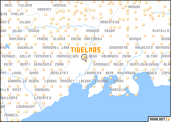
Ti Delmas (Sud, Haiti)Ti Delmas is a town in the Sud region of Haiti. An overview map of the region around Ti Delmas is displayed below.
regional and 3d topo map of Ti Delmas, Haiti ::
Ti Delmas airports ::
The nearest airport is PAP - Port-au-prince Toussaint Louverture Intl, located 148.8 km east of Ti Delmas.
Other airports nearby include CAP - Cap Haitien Intl (223.1 km north east), GAO - Guantanamo Mariana Grajales (253.8 km north west), Nearby towns ::
Christine (NaNkm north) //
Félix (NaNkm north) //
Ca Rosier (NaNkm north) //
Bedo (1.8km east) //
Bonodeau (1.8km east) //
Boileau (1.8km east) //
Grand Dieu (1.9km north) //
Ca Roy (2.6km south east) //
Grand Place (2.6km south east) //
Digo Solon (2.6km north west) //
Malfini (2.6km north west) //
Cavaillon (2.6km north east) //
Dumay (3.5km west) //
Chicot (3.5km west) //
Boulmier (3.5km west) //
Morne Gicard (3.5km west) //
La Porte (3.5km west) //
Delmas (3.7km north) //
La Marche (4.1km south east) //
Flamands (4.1km south east) //
Grand Fond Delmas (4.0km north west) //
LʼAbbey (4.0km north west) //
Gasuire (4.0km north west) //
Grande Savane (4.0km south east) //
Grand Duc (4.0km south east) //
Roche (4.1km north west) //
Durocher (4.0km north east) //
Martineau (4.1km north east) //
Despavines (5.1km south west) //
[all distances 'as the bird flies' and approximate]  Places with similar names to Ti Delmas, Haiti ::
// Titlmoos (DE)
Disclaimer :: Information on this page comes without warranty of any kind |
||
|
Where is Ti Delmas? Elevation and coordinates ::
Latitude (lat): 18°17'0"N Longitude (lon): 73°40'0"W
Elevation (approx.): 15m (map arrows pan, magnifying glasses zoom) |
||
|
Visiting Ti Delmas? Hotel/Accommodation ::
Book a hotel in Ti Delmas Travel Guide ::
Buy a travel guide for Haiti rental cars ::
car rental offers GPS waypoint ::
download a GPX waypoint (PoI) of Ti Delmas for your GPS receiver
|
||