|
search place name
|
||
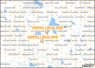
Hammillakulama (North Central, Sri Lanka)Hammillakulama is a town in the North Central region of Sri Lanka. An overview map of the region around Hammillakulama is displayed below.
regional and 3d topo map of Hammillakulama, Sri Lanka ::
Hammillakulama airports ::
The nearest airport is TRR - Trinciomalee China Bay, located 86.4 km north east of Hammillakulama.
Other airports nearby include CMB - Bandaranaike Intl Colombo (131.4 km south west), GOY - Galoya Amparai (160.7 km south east), RML - Colombo Ratmalana (167.0 km south), JAF - Jaffna Kankesanturai (179.6 km north), Nearby towns ::
Gulupettawewa (0.0km north) //
Palayakulama (1.9km north) //
Siyambalagaswewa (1.9km south) //
Puliyankulama (1.8km west) //
Wellamudawa (2.6km south east) //
Kidagala (2.6km north west) //
Ihala Kongaswewa (2.6km north west) //
Pahala Kongaswewa (2.6km north west) //
Kelegama (2.6km south west) //
Kurundankulama (2.6km south west) //
Selettimaduwa (2.6km south west) //
Karuwalagaswewa (2.6km south west) //
Millagahawewa (2.6km south west) //
Pahala Mawatawewa (3.7km east) //
Ihala Mawatawewa (3.7km east) //
Demategama (3.7km east) //
Kuttikulama (3.7km south) //
Tammannagala (3.7km south) //
Wettankulama (3.7km west) //
Kudawewa (4.1km south east) //
Sembukulama (4.1km south east) //
Kunchikulama (4.1km south east) //
Madawalagama (4.1km north west) //
Pandiyankulama (4.1km north west) //
Wagayakulama (4.1km south east) //
Kudagama (4.1km south east) //
Ratmalagahawewa (4.1km south east) //
Kiri Amunukole (4.1km north west) //
Polambayagama (4.1km north west) //
[all distances 'as the bird flies' and approximate]  Places with similar names to Hammillakulama, Sri Lanka ::
// Hammillakulama (LK)
// Hammillakulama (LK)
Disclaimer :: Information on this page comes without warranty of any kind |
||
|
Where is Hammillakulama? Elevation and coordinates ::
Latitude (lat): 8°13'0"N Longitude (lon): 80°28'0"E
Elevation (approx.): 117m (map arrows pan, magnifying glasses zoom) |
||
|
Visiting Hammillakulama? Hotel/Accommodation ::
Book a hotel in Hammillakulama Travel Guide ::
Buy a travel guide for Sri Lanka rental cars ::
car rental offers GPS waypoint ::
download a GPX waypoint (PoI) of Hammillakulama for your GPS receiver
|
||